王金亮教授团队学术论文在SCIE三区期刊《PLOS ONE》上线发表
2023 年 2 月 7 日,以梁磊(云南师范大学地理学部地理信息科学专业2015 级本科生,2019-2022年为中国科学院空天信息创新研究院硕士研究生,现为北京师范大学地理科学学部地图学与地理信息系统专业博士研究生)为第一作者,王金亮教授为通讯作者所撰写的题为“Mapping Pu’er tea plantations from GF-1 images using Object-Oriented Image Analysis (OOIA) and Support Vector Machine (SVM)”的学术论文在SCIE期刊 《PLOS ONE》 (中科院SCI期刊分区:2021年12月最新基础版三区,2022年升级版三区,2022年IF 3.752)上线发表 (https://doi.org/10.1371/journal.pone. 0263969)。
茶叶是世界上最著名饮料植物,中国是茶叶的原产地和最大的生产国,茶叶是中国重要的经济作物,在国内市场与出口贸易中占据着重要的地位。为了能有效管理茶叶种植,为政策制订提供依据,很有必要准确及时地获取茶叶种植区信息。我们提出了一种茶种植区制图方法,基于高分一号(GF-1)影像,综合考虑影像纹理、几何与光谱等特征,利用去相关的分离阈值法(Separability and Thresholds, SEaTH)建立特征空间,采用基于面向对象的支持向量机方法实现茶种植区提取。以普洱茶的源产地之一云南省西双版纳勐海县为例开展研究,结果表明:(1)基于面向对象的支持向量机方法结合纹理信息能够有效解决错分漏分问题,Kappa系数达到0.81,总体精度93.14%,相比CART决策树、最大似然和CNN方法,分别提高了3.61%、0.05,6.99%、0.14和6.44%、0.16。相比二分类方法,多分类方法能够实现更高的精度(2)从2014年到2017年,勐海县茶种植区面积提高了4095.36英亩,2015-2016年增速最快,高达20%。(3)制图结果表明,勐海县的茶种植区主要分布于坡度平缓的居民区附近,这是由于茶叶需要种植于易于排水且交通便利的地区。
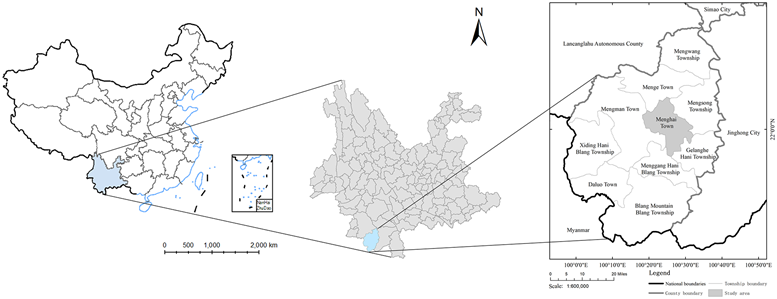
Fig 1. Study area.
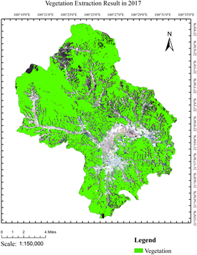
Fig 2. 2017 Vegetation extraction results.The base map of the LandSat8 OLI images with the following composition:R (4),G (3) and B (2). The LandSat8 OLI images were downloaded from USGS National Map Viewer.
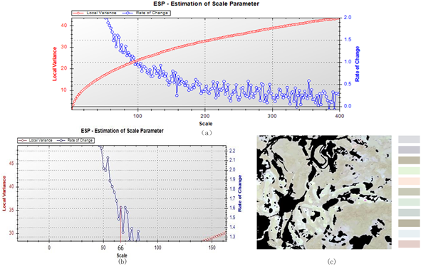
Fig 3. Multiresolution segmentation (SS = 66, WS_1 = 0.5, WC = 0.7): (a) variance curve, (b) optimal segmentation scale and (c) image object.

Fig 4. Tea extraction result. The base map of the LandSat8 OLI images with the following composition:R (4),G (3) and B (2). The LandSat8 OLI images were downloaded from USGS National Map Viewer.
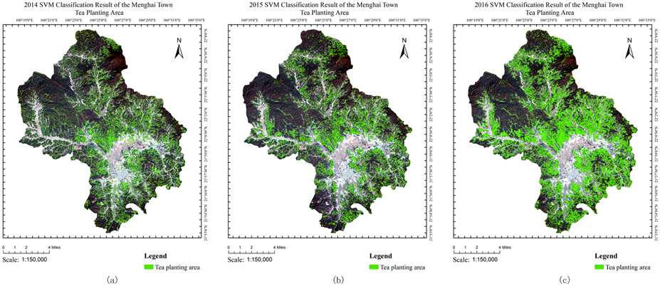
Fig 5. Extraction results in (a)2014 (b)2015 and (c)2016. The base map of the LandSat8 OLI images with the following composition:R (4),G (3) and B (2). The LandSat8 OLI images were downloaded from USGS National Map Viewer.
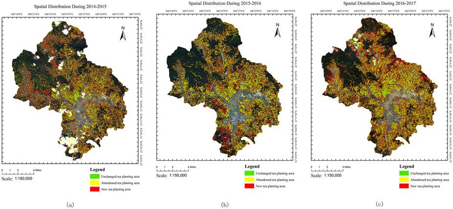
Fig 6. Spatial distribution during (a)2014-2015 (b)2015-2016 and (c)2016-2017. The base map of the LandSat8 OLI images with the following composition:R (4),G (3) and B (2). The LandSat8 OLI images were downloaded from USGS National Map Viewer.
论文得到了王金亮教授主持的云南省高校科技创新团队,国家重点研发计划多政府国际科技创新合作重点项目 “利用地理空间技术进行土地利用/土地覆盖变化对生态安全影响的环境监测与评估”(2018YFE0184300),国家自然科学基金项目 (41561048),云南师范大学大学生科研创新项目(ky2017-072)资助共同资助。
这是梁磊同学本科期间撰写的学术论文(详见录 1、2),也是王金亮教授导师团队 2023年的发表第1篇 SCI/SCIE 论文,让我们恭喜梁磊同学!希望他再接再厉!也祝团队2023年有好成绩!
附录 1 论文相关信息
标题:Mapping Pu'er tea plantations from GF-1 images using Object-Oriented Image Analysis (OOIA) and Support Vector Machine (SVM)
作者:Lei Liang .1,2,3– Jinliang Wang. 1,2,3,* –Fei Deng. 1,2,3–Deyang Kong. 1,2,3
通讯作者:Jinliang Wang
作者单位:
1 Faculty of Geography, Yunnan Normal University, Kunming, Yunnan, 650500, China
2 Key Laboratory of Resources and Environmental Remote Sensing for Universities in Yunnan Kunming, Yunnan, 650500, China
3 Remote Sensing Research Laboratory, Center for Geospatial Information Engineering and Technology of Yunnan Province, Kunming 650500, China
* Correspondence: E-mail: jlwang@ynnu.edu.cn; Tel.: 86 871 65941198
出版物: PLOS ONE
摘要:
Tea is the most popular drink worldwide, and China is the largest producer of tea. Therefore, tea is an important commercial crop in China, playing a significant role in domestic and foreign markets. It is necessary to make accurate and timely maps of the distribution of tea plantation areas for plantation management and decision making. In the present study, we propose a novel mapping method to map tea plantation. The town of Menghai in the Xishuangbanna Dai Autonomous Prefecture, Yunnan Province, China, was chosen as the study area, andgg GF-1 remotely sensed data from 2014-2017 were chosen as the data source. Image texture, spectral and geometrical features were integrated, while feature space was built by SEparability and THresholds algorithms (SEaTH) with decorrelation. Object-Oriented Image Analysis (OOIA) with a Support Vector Machine (SVM) algorithm was utilized to map tea plantation areas. The overall accuracy and Kappa coefficient ofh the proposed method were 93.14% and 0.81, respectively, 3.61% and 0.05, 6.99% and 0.14, 6.44% and 0.16 better than the results of CART method, Maximum likelihood method and CNN based method. The tea plantation area increased by 4,095.36 acre from 2014 to 2017, while the fastest-growing period is 2015 to 2016.
关键字:Change detection, Feature selection, OOIA, Pu'er tea, SVM
附录2 梁磊同学发表SCI论文清单
梁磊同学在王金亮教授指导下发表了1篇SCI学术论文,信息如下:
[1] Mapping Pu'er tea plantations from GF-1 images using Object-Oriented Image Analysis (OOIA) and Support Vector Machine (SVM)[J]. PLOS ONE, 2023. DOI: https://doi.org/10.1371/journal.pone. 0263969 (中科院SCI期刊分区:2021年12月最新基础版三区,升级版三区,2022年IF 3.752)
(云南高校资源与环境遥感重点实验室 供稿)
地址:云南省昆明市呈贡区云南师范大学旅游与地理科学学院413
邮箱:ynnurs@163.com 电话:0871-65941202 技术支持:蓝队云
版权所有:Copyright © 2016-2018 云南省高校资源与环境遥感重点实验室. All Rights Reserved