资源与环境遥感团队学术论文在SCIE二区期刊Ecology and Evolution上线发表
2024年8月9日,以刘芳(云南师范大学地理学部地图学与地理信息系统专业2018级博士研究生)为第一作者,王金亮教授为通讯作者所撰写的题为“Ecological security assessment of Yunnan Province, China in the context of Production-Living-Ecological Space division”的学术论文在SCIE二区期刊Ecology and Evolution上线发表(https://doi.org/10.1002/ece3.70131)。
生态安全已经成为国家安全的组成部分,成为区域、国家可持续发展研究的重要内容。为应对全球面临生态系统退化、生物多样性丧失、土地沙化和水土流失加剧、水气土壤污染等环境问题而提出生态安全评价研究,以可持续科学的关键科学问题为核心。生态安全研究是应对全球环境问题,实现人类可持续发展的重要途径。
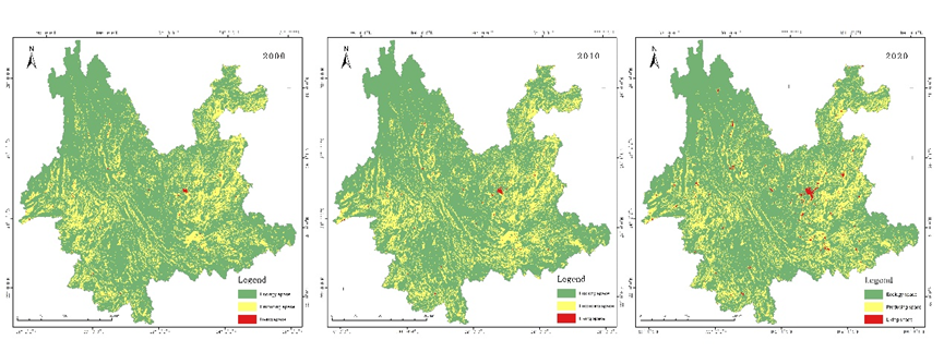
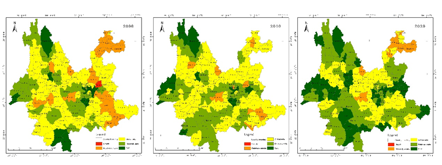
我们发现,云南省三生空间格局以生态空间为主导占比在75%,生产空间占比其次为23%,生活空间仅占不到1%,2000-2020年生态空间有所缩减,生产空间和生活空间呈扩张趋势,体现了云南省以生态功能为主,生产和生活空间均在快速发展,同时由于土地资源的稀缺性,导致生态保护与发展的矛盾一直存在。云南省生产空间生态安全2010年较2000年呈好转,但2020年生产空间生态安全又大幅下降。生产空间安全区主要是分布在滇西的德宏州和滇南的西双版纳,这些区域水热条件较好适宜生产。不安全区主要分布在滇中的昆明和红河州北部,生产空间生态安全有明显的行政区特征,是由于不同行政区内生产条件和投入情况对生产空间生态安全影响。云南省生活空间生态安全在2000-2020年生态空间和呈好转趋势。生活空间安全区主要是分布在滇中的昆明市,昆明市作为云南省省会城市,基础设施与政府投入都较好,因此生活空间生态安全保障相对较为全面。其他州市差异相对较小,整体呈现东部优于西部,南部优于北部的特征。2020年较2000年和2010年生活空间生态安全整体有较大改善。云南省生态空间生态安全在2000-2020年生态空间和呈好转趋势,2000年与2010年变化小于2010与2020年的差异。生态空间安全区主要是分布在滇西北和滇南,也是云南省生态较敏感和脆弱的地区,是云南省生态保护措施实施较好的区域。不安全区主要分布在滇中、滇东北和滇东南,滇中是云南省社会经济发展与生态保护矛盾较为突出的区域,滇东北和滇东南的生态安全则是受地形、气候等自然条件限制。

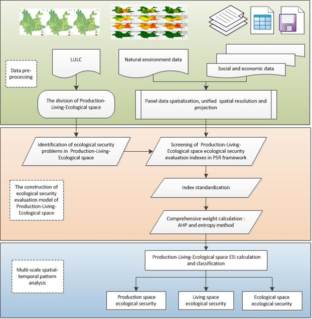
Fig. 1. Technical route of the research.

Fig. 2. Results of PLES in Yunnan Province

Fig. 3. Maps of production space ecological security on County-scale
该论文得到了王金亮教授主持的云南省科技重大专项(西南联合研究生院科技专项基础研究与应用基础研究重大专项,批准号202302AO370003);云南省科技厅社发重点研发项目(批准号202203AC100001);科技部政府间合作重点专项(批准号2018YFE0184300)共同资助。
这是刘芳同学博士期间以第一作者发表的第2篇SCIE论文(详见附录1、附录2),此篇论文也是王金亮教授导师团队2024年发表的第10篇SCIE/SSCI论文(详见附录3)。让我们恭喜刘芳同学!希望她再接再厉!也热烈祝贺资源与环境遥感研究团队取好成绩!
附录 1 论文相关信息
标题:Ecological security assessment of Yunnan Province, China in the context of Production-Living-Ecological Space division
作者:Fang Liu a,b,c,d, Qian Zhang d, Jinliang Wang a,b,c*, Yuexiong Liu d, Wanbin Wangd, Sen Li d
通讯作者:Jinliang Wang
作者单位:
a Faculty of Geography, Yunnan Normal University, Kunming 650500, China;
b Key Laboratory of Resources and Environmental Remote Sensing for Universities in Yunnan, Kunming 650500, China
c Center for Geospatial Information Engineering and Technology of Yunnan Province, Kunming 650500, China
d Yunnan Academy of Ecological and Environmental Sciences, Kunming 650034, Yunnan, China
出版物:Ecology and Evolution(中科院SCI期刊分区:2023年12月最新升级版二区,2024年IF:2.8)
摘要:With the rapid development of population, society and economy, human activities have caused serious adverse impacts on the environment, ecosystems and landscape patterns over the long term. In order to address the series of impacts of human activities on the environment, territorial space, and resource use, the study of Production-Living-Ecological Space(PLES) and ecological security have all become academic frontiers in the field of sustainable development. In this study, we applied multi-source data and GIS technology to construct an ecological security evaluation model based on the results of PLES delineation and the PSR framework, and carried out the three-period PLES ecological security evaluation for 2000, 2010 and 2020 at the county and grid scales in Yunnan Province. The PLES pattern in Yunnan Province is dominated by ecological space, which accounts for 75%, followed by 23% of production space, with ecological space shrinking from 2000 to 2020. Ecological security in ecological space and living space shows an improving trend from 2000 to 2020. The ecological security of production space improved in 2010 compared to 2000 but then showed a decreasing trend in 2020. Ecological security in ecological space shows that northwestern and southern Yunnan is safer than central Yunnan, while ecological security in living space is safer in central Yunnan, and ecological security in production space is better in southern Yunnan than in northern Yunnan. Comparison with related research results shows that the ecological security evaluation results of PLES in Yunnan Province in this study are scientific and reasonable. The ecological security evaluation model of PLES constructed in this study solves the problem of complex and incomplete ecological security evaluation indexes in the past, and the results of the study are more refined and precise, which provides new ideas for the study of regional ecological security.
关键词:Territorial space zoning; Ecological Security; PSR model; Multiscale
附录 2 刘芳同学发表论文清单
自2018年9月攻读博士至今,刘芳在王金亮教授指导下共发表了2篇SCIE学术论文,信息如下:
[1]Fang Liu, Qian Zhang, Jinliang Wang*, Yuexiong Liu, Wanbin Wang, Sen Li. Ecological security assessment of Yunnan Province, China in the context of Production-Living-Ecological Space division[J]. Ecology and Evolution. 2024.14, e70131. https://doi.org/10.1002/ece3.70131. (中科院SCI期刊分区:2023年12月最新升级版二区,2024年IF:2.3)
[2]Fang Liu, Wanbin Wang, Jinliang Wang*, Xingzi Zhang, Jing Ren, Yuexiong Liu . Multi-scale analysis of the characteristics of the changing landscape of the typical mountainous region of Southwest China over the past 40 years [J]. PeerJ. 2021. DOI: https://doi.org/10.7717/peerj.10923 (中科院SCI期刊分区:2023年12月最新升级版三区,2024年IF:2.3)
附录 3王金亮教授团队 2024 年发表论文清单
自2024年01月01日至08月17日,王金亮教授导师团队发表学术论文10篇(仅统计王金亮教授为通讯作者的论文),其中SCIE论文9篇、SSCI论文1篇。具体信息如下:
[10] Fang Liu, Qian Zhang, Jinliang Wang*, Yuexiong Liu, Wanbin Wang, Sen Li. Ecological security assessment of Yunnan Province, China in the context of Production-Living-Ecological Space division[J]. Ecology and Evolution. 2024.14, e70131.https://doi.org/10.1002/ece3.70131(中科院 SCI 期刊分区:2023 年 12 月最新分区二区,IF:2.3)
[9] Liu, S.; Deng, Y.; Zhang, J.; Wang, J.*; Duan, D. Extraction of Arbors from Terrestrial Laser Scanning Data Based on Trunk Axis Fitting[J]. Forests, 2024, 15, 1217. https:// doi.org/10.3390/f15071217(中科院 SCI 期刊分区:2023 年 12 月最新分区二区,IF:2.4)
[8] Jie Li, Jinliang Wang*, Suling He, Chenli Liu, Lanfang Liu. Using Knowledge Graphs to Analyze the Characteristics and Trends of Forest Carbon Storage Research at the Global Scale [J]. ISPRS International Journal of Geo-Information, 2024, 13(7), 234. DOI: https://doi.org/10.3390/ijgi13070234. (中科院SCI期刊分区:2023年12月最新升级版三区,2024年IF:2.8)
[7] Suling He, Jinliang Wang*, Jie Li, Jinming Sha, Jinzhun Zhou, Yuanmei Jiao, Quantification and Simulation of the Ecosystem Service Value of Karst Region in Southwest China[J], Land, 2024, 13(6): 812. https://doi.org/10.3390/land13060812. (中科院 SCI 期刊分区:2023年12月最新升级版SSCI二区,2024年IF:3.9)
[6] Lanfang Liu, Yan Liu, Feng Cheng, Yuanhe Yu, Jinliang Wang*, Cheng Wang , Lanping Nong, Huan Deng, Remote sensing estimation of regional PM2.5 Based on GTWR Model -A case study of southwest China[J], Environmental Pollution, 2024, 124057. https://doi.org/10.1016/j.envpol.2024.124057 (中科院SCI期刊分区:2023年12月最新升级版二区Top期刊,2024年IF:8.9)
[5] Rafael Antonio Chaparro Torres, Jinliang Wang, Jianpeng Zhang, Lanfang Liu, Yongcui Lan, Temporal analysis of land degradation and urban expansion in central Yunnan Province using remote sensing for supporting sustainable development goals 11/15[J], Ecological Indicators, Volume 163, 2024, 112058. https://doi.org/10.1016/j.ecolind.2024.112058 (中科院SCI期刊分区:2023年12月最新升级版二区Top期刊,2024年IF:6.9)
[4] Gao, Y., Wang, J. *, Liu, S. *, Yao, X., Qi, M., Liang, P., Xie, F., Mu, J., Ma, X. Monitoring dynamics of Kyagar Glacier surge and repeated draining of Ice-dammed lake using multi-source remote sensing[J]. Science of The Total Environment, 2024, 172467. https://doi.org/10.1016/j.scitotenv.2024.172467 (中科院SCI期刊分区:2023年12月最新升级版一区Top期刊,2024年IF:9.8)
[3] Xu, Haichao, Rongqing Han, Jinliang Wang*, and Yongcui Lan. Temporal–Spatial Characteristics and Influencing Factors of Forest Fires in the Tropic of Cancer (Yunnan Section) [J]. Forests, 2024, 15, 661. https://doi.org/10.3390/f15040661 (中科院SCI期刊分区:2023年12月最新升级版二区,2024年IF:2.9)
[2] Yanke Zhang, Tengfei Gu, Suling He, Feng Cheng, Jinliang Wang*, et al. Extreme drought along the tropic of cancer (Yunnan section) and its impact on vegetation[J]. Scientific reports, 2024, 14, 7508. https://doi.org/10.1038/s41598-024-58068-w. (中科院SCI期刊分区:2023年12月最新升级版二区,2024年IF:4.6)
[1] Di Duan, Yuncheng Deng, Jianpeng Zhang, Jinliang Wang*, et al. Influence of VF and SOR-Filtering Methods on Tree Height Inversion Using Unmanned Aerial Vehicle LiDAR Data[J]. Drones, 2024, 8(4), 119. https://doi.org/10.3390/drones8040119. (中科院SCI期刊分区:2023年12月最新升级版二区,2024年IF:4.8)
(云南省高校资源与环境遥感重点实验室 供稿)
地址:云南省昆明市呈贡区云南师范大学旅游与地理科学学院413
邮箱:ynnurs@163.com 电话:0871-65941202 技术支持:蓝队云
版权所有:Copyright © 2016-2018 云南省高校资源与环境遥感重点实验室. All Rights Reserved