资源与环境遥感团队吴风志学术论文在SCIE一区TOP期刊Industrial Crops & Products上线发表!!
2025年04月10日,以吴风志(云南师范大学地理学部地图学与地理信息系统专业2024级博士生)为第一作者,王金亮教授为通讯作者所撰写的题为“Prediction and quality zoning of potentially suitable areas for Panax notoginseng cultivation using MaxEnt and random forest algorithms in Yunnan Province, China”的学术论文在SCI/SCIE一区TOP期刊《Industrial Crops & Products》上线发表(https://doi.org/10.1016/j.indcrop.2025.120960)。
(一)文章信息
标题:Prediction and quality zoning of potentially suitable areas for Panax notoginseng cultivation using MaxEnt and random forest algorithms in Yunnan Province, China
l 期刊:《Industrial Crops & Products》(中科院1区Top, IF=5.6)
l 作者:Fengzhi Wu, Yong Wang, Maihong Zheng, Jinliang Wang*, Jiya Pan, Lanfang Liu.
l doi:https://doi.org/10.1016/j.catena.2024.108689
(二)研究背景
三七(Panax notoginseng)作为我国特色药用植物栽培体系中的关键品种,在推动乡村振兴、增加农民收入和促进区域经济发展中发挥着重要作用。其根部富含多种具有活性的皂苷类成分,具有活血化瘀、保护心脑血管等显著功效,是临床广泛应用的大宗中药材之一。当前,三七野生资源在全球范围内已基本灭绝,完全依赖人工栽培。由于其对光照、水分、土壤等生态因子高度敏感,适宜栽培区主要分布在云南、广西和贵州等地,尤其是云南省,不仅是三七的原产地和主产区,更承担了全国超过98%的栽培面积和产量,其相关产业产值占云南中药材产业总值的一半以上,具有不可替代的核心地位。然而,长期沿用的传统农田栽培模式导致连作障碍严重,林下栽培模式虽可缓解部分问题,但受限于光照调控和土壤改良等技术瓶颈,尚未实现规模化推广,难以支撑商业化生产需求。在生产压力推动下,三七栽培区不断向滇中、滇西等非传统区域扩展,但因缺乏系统的生态适宜性和品质潜力评估,出现了“扩区无序、品质下滑、生态脆弱加剧”的风险。因此,研究基于实地采样的栽培数据,集成多源生境因子,构建MaxEnt与随机森林耦合模型,开展云南省三七潜在适宜栽培区预测与品质区划。研究结果可为优化三七种植布局、提升中药材道地质量、推动产业高质量发展提供科学依据和技术支撑。
(三)数据与方法
研究使用的数据主要包括三七生境因子与栽培样本数据:数据整合自ASTER GDEM、WorldClim 2.1气象数据库、TCM-GIS系统、云南气象局插值数据,以及HWSD土壤数据库和全国第二次土壤普查成果;栽培样本数据通过实地采集与实验检测获得,包括164对三七栽培样区的空间坐标信息,以及104份三年生三七主根样品的总皂苷(R1+Rg1+Rb1)含量测定值。研究所用方法如下:(1)MaxEnt模型用于预测三七潜在栽培适宜区,并解析影响栽培适宜性的关键生境因子;(2)GeoDetector用于探测影响三七主根总皂苷含量的主导生境因子;(3)PCA用于提取主导生境因子的主分量;(4)Random Forest算法用于在适宜区内开展三七品质区划。
(四)研究结果
(1)云南省23.26%的区域适宜三七栽培,呈典型"核心-边缘"空间分异:高适宜区(21.53%),集中分布于文山西部与西南部、红河中部与东部,以及红河、曲靖、昆明三地交界处;中、低适宜区分别占30.92%和47.55%,呈放射状环绕高适宜区分布。(2)三七生长的最优生态位特征组合:中海拔缓坡、温和的年气温波动及最干季缓冲型降水。(3)三七主根皂苷积累受环境调控显著,中海拔、高湿度、低太阳辐射及昼夜温差小的生境更有利于提升主根皂苷含量。(4)基于主根总皂苷含量,三七栽培适宜区中,高质区、中质区和一般质量区分别占26.69%、37.38%和35.93%。适宜性分布与品质区划之间存在明显的空间错配。
(五)研究结论
(1)基于MaxEnt模型和Random Forest算法构建的“生境适宜性-质量”双维度评价框架,有效揭示了云南省三七潜在适宜栽培区的空间分布及其质量分异机制。(2)三七栽培适宜性主要受纬度、年降水量与气温年较差等地理气候因子共同调控,而海拔、降水季节性与≥10℃积温等则是三七主根皂苷合成的主要驱动因子,进而形成分布集中、特征突出的三七优质核心产区。(3)为破解“连作障碍-栽培区转移-生态退化”恶性循环,应严格限制低适宜区扩种,优化中低质量区的土壤理化条件与微环境调控,并将双维分区标准纳入道地药材管理体系,推动三七产业由“规模优先”向“质量–生态协同”转型。
(六)主要图表
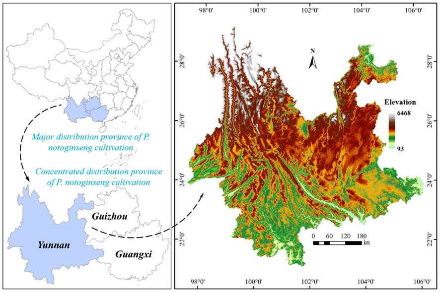
Fig. 1. The location of the study area
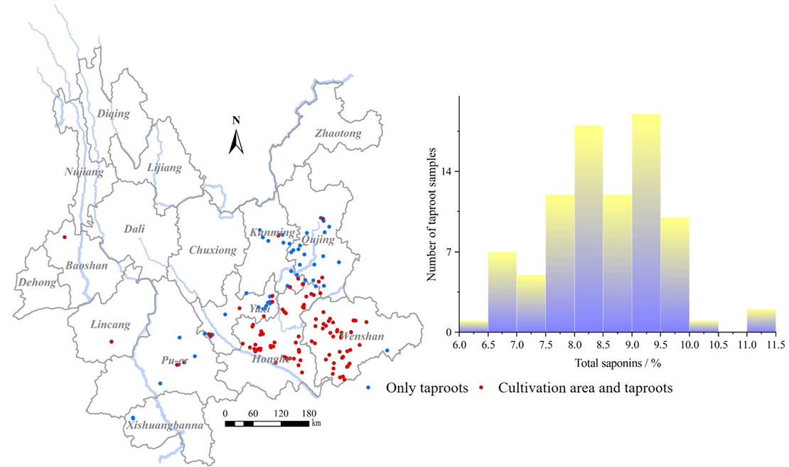
Fig. 2. Sampling locations
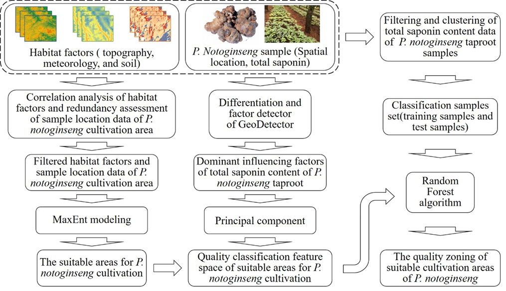
Fig. 3. Processes for the prediction and quality zoning of potentially suitable areas for P. notoginseng cultivation
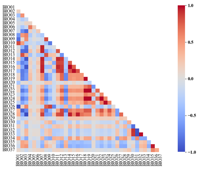
Fig. 4. The correlation coefficient matrix of habitat factors
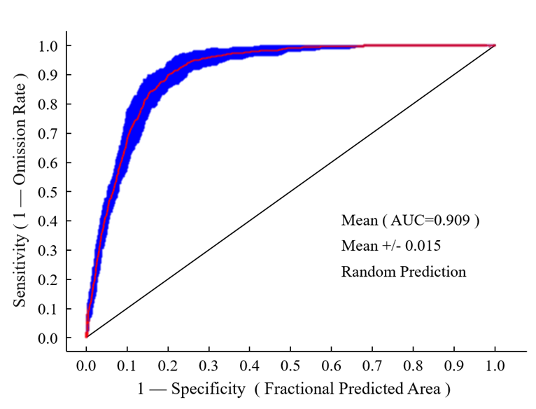
Fig. 5. The receiver operating characteristic curve
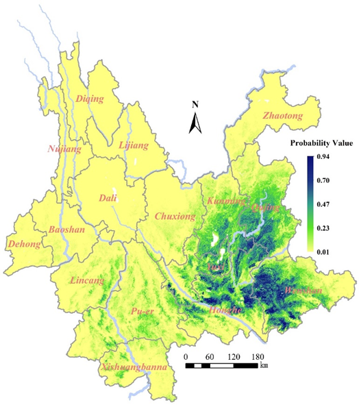
Fig. 6. The prediction results
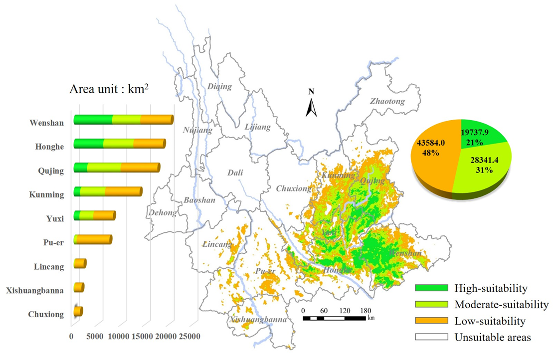
Fig. 7. The spatial distribution of different suitability areas for P. notoginseng cultivation
Table 1. Data type and source
Data | Type | Resolution or Scale | Specific Indicators | Data source and explanation |
Topographic data | Raster | 90 m | Tab. 2: BIO01 to BIO06 | Geospatial Data Cloud (https://www.gscloud.cn) |
Meteorological data | Raster | 1000 m | Tab. 2: BIO07 to BIO28 | 1. WorldClim 2.1 database (https://www.worldclim.org/) 2.The TCM-GIS system of the Institute of Medicinal Plant Development, Chinese Academy of Medical Sciences 3. Yunnan Meteorological Bureau |
Soil data | Raster | 1000 m | Tab. 2: BIO29 to BIO37 | 1. Harmonized World Soil Database (HWSD) (https://www.fao.org/soils-portal/data-hub/soil-maps-and-databases/harmonized-world-soil-database-v20/en/) 2. China's second national survey on soils in 2000 |
Basic geographic information data | Vector | 1:10,000,000 | Administrative divisions, river systems | National Geographic Information Public Service Platform (https://www.tianditu.gov.cn/) |
Table 2. Selected habitat factors for the study
Encoding | Habitat factors | Encoding | Habitat factors |
BIO01 | Longitude (°) | BIO20 | Precipitation of Driest Month (mm) |
BIO02 | Latitude (°) | BIO21 | Precipitation Seasonality (%) |
BIO03 | Elevation (m) | BIO22 | Precipitation of Wettest Quarter (mm) |
BIO04 | Slope (°) | BIO23 | Precipitation of Driest Quarter (mm) |
BIO05 | Aspect (°) | BIO24 | Precipitation of Warmest Quarter (mm) |
BIO06 | Surface Relief (m) | BIO25 | Precipitation of Coldest Quarter (mm) |
BIO07 | Annual Mean Temperature (°C) | BIO26 | Annual Mean Solar Radiation Intensity (W/m2) |
BIO08 | Mean Diurnal Range (°C) | BIO27 | Annual Mean Relative Humidity (%) |
BIO09 | Isothermality (%) | BIO28 | ≥10 °C Accumulated Temperature (°C) |
BIO10 | Temperature Seasonality (%)) | BIO29 | Volume Percentage of Coarse Fragments in Soil (%) |
BIO11 | Max Temperature of Warmest Month (°C) | BIO30 | Sand Content of Soil (%) |
BIO12 | Min Temperature of Coldest Month (°C) | BIO31 | Clay Content of Soil (%) |
BIO13 | Temperature Annual Range (°C) | BIO32 | Texture Class of Soil |
BIO14 | Mean Temperature of Wettest Quarter (°C) | BIO33 | Bulk Density of Soil (g/cm³) |
BIO15 | Mean Temperature of Driest Quarter (°C) | BIO34 | Organic Carbon Content of Soil (%) |
BIO16 | Mean Temperature of Warmest Quarter (°C) | BIO35 | pH of Soil (PH) |
BIO17 | Mean Temperature of Coldest Quarter (°C) | BIO36 | Basic Saturation of Soil (%) |
BIO18 | Annual Precipitation (mm) | BIO37 | Calcium Carbonate of Soil (%) |
BIO19 | Precipitation of Wettest Month (mm) |
Table 2. Selected habitat factors for the study
Encoding | Habitat factors | Encoding | Habitat factors |
BIO01 | Longitude (°) | BIO20 | Precipitation of Driest Month (mm) |
BIO02 | Latitude (°) | BIO21 | Precipitation Seasonality (%) |
BIO03 | Elevation (m) | BIO22 | Precipitation of Wettest Quarter (mm) |
BIO04 | Slope (°) | BIO23 | Precipitation of Driest Quarter (mm) |
BIO05 | Aspect (°) | BIO24 | Precipitation of Warmest Quarter (mm) |
BIO06 | Surface Relief (m) | BIO25 | Precipitation of Coldest Quarter (mm) |
BIO07 | Annual Mean Temperature (°C) | BIO26 | Annual Mean Solar Radiation Intensity (W/m2) |
BIO08 | Mean Diurnal Range (°C) | BIO27 | Annual Mean Relative Humidity (%) |
BIO09 | Isothermality (%) | BIO28 | <span style="font-family:'Times New |
地址:云南省昆明市呈贡区云南师范大学旅游与地理科学学院413
邮箱:ynnurs@163.com 电话:0871-65941202 技术支持:蓝队云
版权所有:Copyright © 2016-2018 云南省高校资源与环境遥感重点实验室. All Rights Reserved