王金亮教授团队学术论文在SCIE二区期刊Drones上线发表
2024年03月23日,以段迪(云南师范大学地理学部地图学与地理信息系统专业2022级硕士)为第一作者,王金亮教授为通讯作者所撰写的题为“Influence of VF and SOR-Filtering Methods on Tree Height Inversion Using Unmanned Aerial Vehicle LiDAR Data”的学术论文在SCIE二区期刊《Drones》上线发表(https://doi.org/10.3390/drones8040119).
森林是陆地生态系统的主体,其结构参数的精确提取一直是大家关注的问题。机载LiDAR技术的出现为森林树高等参数获取提供了有力保障,然而,机载LiDAR点云数据存在体量大,数据冗余等问题,导致森林参数反演效率较低,而不同的点云数据数据处理方法效果差异较大。研究通过体素滤波和统计滤波点云数据处理实验分析,探究不同滤波方法对森林树高参数反演效率与精度的影响。结果表明:(1)体素滤波数据处理在点云数量、文件大小、运行时间等方面优势明显高于统计滤波,,前者点云数量较原始点云数量平均减少96.91%,后者平均减少13.19%;前者文件大小较原始文件大小平均减少96.91%,后者平均减少13.20%;前者平均运行时间7.48秒,后者平均运行时间9.85秒;(2)经体素滤波处理后数据反演树高精度优于统计滤波处理后的数据反演树高,前者平均精度为96.24%,后者为94.17%。综上所述,体素滤波能够有效降低数据冗余,提高树高反演精度。
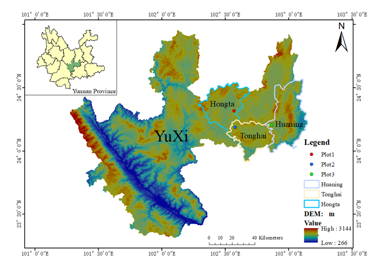
Fig. 1. Location of the study plots
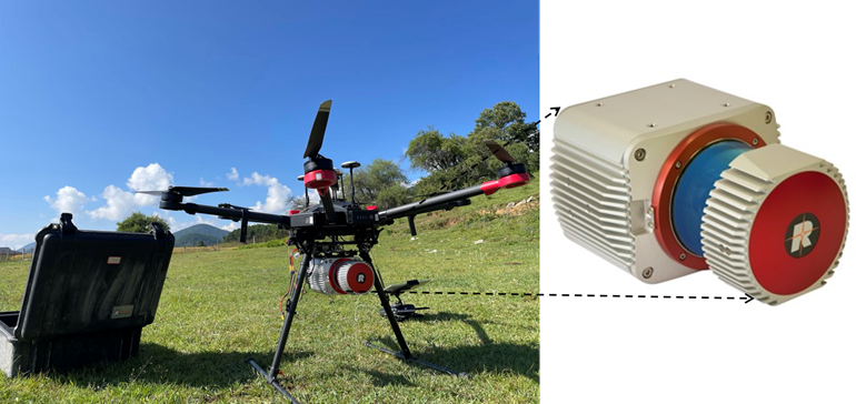
Fig. 2. UAV-LiDAR system
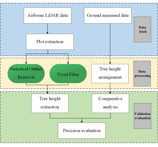
Fig. 3. Data process flow
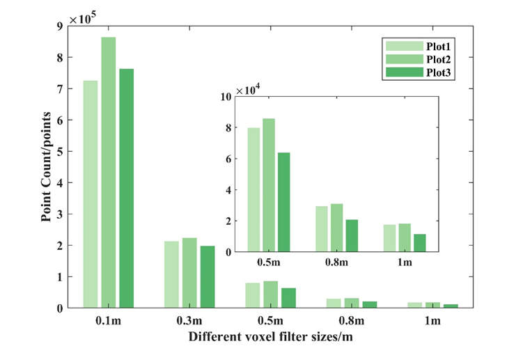
Fig. 4. Comparison of the number of point clouds with different voxel filter sizes
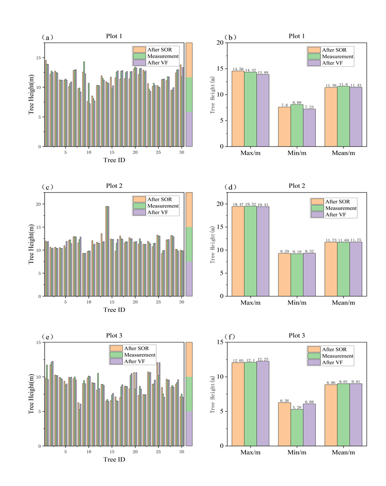
Fig. 5. Comparison of tree height
该论文得到了王金亮教授主持的西南联合研究生院科技专项-基础研究和应用基础研究重大项目:云南金沙江流域矿区植被多模态遥感动态监测及生态修复模式研究(项目编号:202302AO370003);云南省科技人才与平台计划外国人才引进专项-重点(编号: 202305A0350006);国家自然科学基金项目(编号: 41961060);云南省高校创新团队(云南省高校高原山地资源环境遥感监测与评估科技创新团队),教育部科研基金项目云南省(编号:2023Y0521)的共同资助。
这是段迪同学硕士期间以第一作者发表的第1篇SCIE学术论文(详见附录 1),此篇论文也是王金亮教授导师团队 2024年发表的第1篇 SCI/SCIE 论文,让我们恭喜段迪同学!希望他再接再厉!也热烈祝贺团队取好成绩!
附录 1 论文相关信息
标题:Influence of VF and SOR-Filtering Methods on Tree Height Inversion Using Unmanned Aerial Vehicle LiDAR Data
作者:Di Duan 1,2,3,4, Yuncheng Deng 1,2,4, Jianpeng Zhang 1,2,4, Jinliang Wang 1,2,3,4,* and Pinliang Dong 5
通讯作者:Jinliang Wang
作者单位:
1 Faculty of Geography, Yunnan Normal University, Kunming 650504, China
2 Key Laboratory of Resources and Environmental Remote Sensing for Universities in Yunnan, Kunming 650504, China
3 Southwest United Graduate School, Kunming 650092, China
4 Remote Sensing Research Laboratory, Center for Geospatial Information Engineering and Technology of Yunnan Province, Kunming 650504, China
5 Department of Geography and Environment, University of North Texas, Denton, TX 76203, USA; pinliang.dong@unt.edu
* Corresponding author:
E-mail: jlwang@ynnu.edu.cn
出版物:Drones
摘要:
Forests, as the main body of the terrestrial ecosystem, have long been focal points for accurate structural parameter extraction. Among these parameters, tree height is a fundamental measurement factor that plays an important role in monitoring forest structure and biomass. The emergence of unmanned aerial vehicle light detection and ranging (UAV-LiDAR) technology has provided a strong guarantee of the acquisition of forest tree height parameters. However, UAV-LiDAR point cloud data have problems such as a large volume and data redundancy, and different point cloud data processing methods have different effects. Based on voxel filtering (VF) and statistical outlier removal (SOR)point cloud data processing experimental analysis, this study explored the influence of different filtering methods on the forest tree height inversion efficiency and accuracy. First, the point cloud data processed by VF is significantly better than that of SOR in terms of point cloud number, file size, running time, etc. The number of point clouds for VF decreased by an average of 96.91% compared with the original point clouds. Second, the VF tree height inversion accuracy was better than the tree height inversion data using SOR. The average accuracy of VF was 96.24%, while that of SOR was 94.17%. In summary, VF can effectively reduce data redundancy and improve tree height inversion accuracy.
关键字:airborne LiDAR; UAV-LiDAR; voxel filtering; statistical outlier removal; tree height inversion; forest parameters
附录 2 王金亮教授团队 2024 年发表论文清单
自2024年01月01日至03月23日,王金亮教授导师团队发表学术论文1篇(仅仅统计王金亮教授为通讯作者的论文),其中SCIE论文1篇。具体信息如下:
[1] Di Duan, Yuncheng Deng, Jianpeng Zhang, Jinliang Wang*, et al. Influence of VF and SOR-Filtering Methods on Tree Height Inversion Using Unmanned Aerial Vehicle LiDAR Data, Drones. 2024,8(4), 119. https://doi.org/10.3390/drones8040119 .
(云南省高校资源与环境遥感重点实验室 供稿)
地址:云南省昆明市呈贡区云南师范大学旅游与地理科学学院413
邮箱:ynnurs@163.com 电话:0871-65941202 技术支持:蓝队云
版权所有:Copyright © 2016-2018 云南省高校资源与环境遥感重点实验室. All Rights Reserved