王金亮团队学术论文在SCIE期刊Remote Sensing上线发表
2023年6月26日,以李杰(云南师范大学地理学部地图学与地理信息系统专业2020级博士研究生)为第一作者,王金亮教授为通讯作者所撰写的题为“Combining Multi-Source Data and Feature Optimization for Plastic-Covered Greenhouse Extraction and Mapping Using the Google Earth Engine: A Case in Central Yunnan Province, China”的学术论文在SCIE期刊Remote Sensing上线发表(https://www.mdpi.com/2072-4292/15/13/3287)。
高效的温室大棚(plastic-covered greenhouse,PCG)制图对于监测农业活动和评估环境影响至关重要。然而,PCG遥感检测仍然存在许多挑战,如多源数据组合、分类精度提高、时空尺度扩展和动态趋势量化。为了解决这些问题,我们在滇中地区率先开展了PCG遥感制图研究。我们关注的科学问题是如何在大规模复杂地形条件下构建一个通用、高效、高精度、可移植的PCG自动识别框架,以解释区域PCG的时空动态,为区域现代农业经济生产和可持续发展提供新的见解。我们相信这项研究具有重要的学术和应用意义。对于前者,我们开创了一个基于机器学习分类算法、特征优化算法和谷歌地球引擎云平台的系统框架,以渐进的方式快速提取大面积PCG。对于应用价值,我们首先将该框架应用于PCG集中但缺乏相关研究的滇中地区区域,以实现区内2016年至2021年10米级分辨率的PCG图谱绘制,并进一步分析了其时空格局。值得注意的是,该框架可以移植到其他区域进行大规模的PCG快速提取。
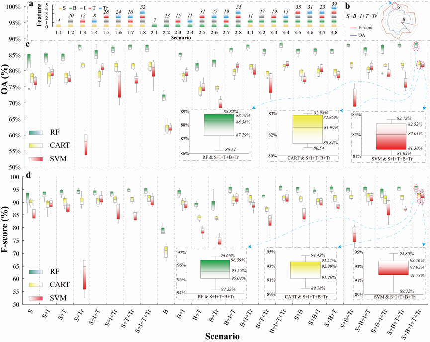
实践中,我们发现PCG的提取精度受到特征类别和数量的影响,整合更多的特征会带来更高的精度。然而,多个特征的组合不仅仅是简单的特征叠加,而是合理的组合,实验证明,特征优化对PCG识别有积极影响。精度评价结果表明,本研究提取的PCG的6年平均F测度超过95.00%,并通过了卫星图像和野外无人机图像的视觉检查;此外,本研究的分类结果优于相关产品(如GLOBELAND30数据、ESA WorldCover数据、2019中国10米分辨率PCG专题数据),表明本研究提出的PCG检测框架是科学可靠的。总之,基于GEE平台,可以通过特征优化算法整合多源数据,以更有效地识别复杂区域背景下的PCG分布信息。

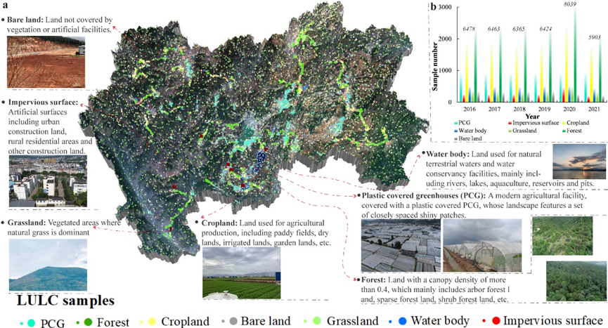
Figure 1. LULC Samples: (a) final LULC sample library formed from field-collected LULC samples (larger points) and the visually expanded samples (smaller points); (b) the number of various LULC samples from 2016 to 2021.

Figure 2. Accuracy evaluation of the combination of feature scenarios and classifiers: (a) feature scenarios, where S, B, I, T, and Tr represent spectrum, backscatter, index, texture, and terrain features, respectively; (b) average accuracy for different feature scenarios; (c) OA of different classifiers based on different feature scenarios; (d) F-score of different classifiers based on different feature scenarios.

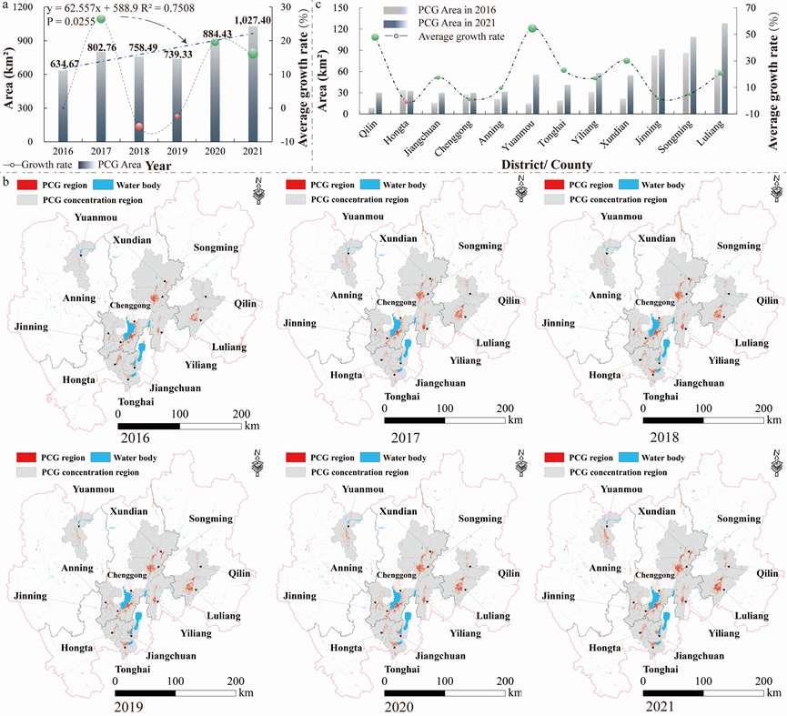
Figure 3. Spatiotemporal features of PCGs extracted in CYP from 2016 to 2021: (a) temporal changes in PCGs; (b) annual spatial distribution of PCGs; (c) PCG changes in regions where they are concentrated.

Figure 4. Visual comparison of LULC/PCG datasets produced by the current study with (a) GLOBALAND30 products and ESA WorldCover products; (b) the 2019 China 10-metre resolution PCG thematic data. I–V are demonstration zones for further detailed comparison.
该论文得到了王金亮教授主持的国家重点研发计划政府间国际科技创新合作重点专项:用地理空间技术监测和评估土地利用/土地覆被变化对区域生态安全的影响(2018YFE0184300),国家自然科学基金“基于ULS和TLS云点数据的滇西北天然林生物量估算”(41961060),云南省高校高原山地资源环境遥感监测与评估科技创新团队(IRTSTYN)的资助。
这是李杰同学博士期间以第一作者发表的第4篇SCIE学术论文(详见录 1,2),也是王金亮教授导师团队 2023年发表的第4篇 SCI/SCIE 论文(详见录 3),让我们恭喜张建鹏同学!希望他再接再厉!也热烈祝贺团队取好成绩!
附录 1 论文相关信息
标题:Combining Multi-Source Data and Feature Optimization for Plastic-Covered Greenhouse Extraction and Mapping Using the Google Earth Engine: A Case in Central Yunnan Province, China
作者:Jie Li 1,2,3, Hui Wang 1,2,3, Jinliang Wang 1,2,3,*, Jianpeng Zhang 1,2,3, Yongcui Lan 1,2,3, Yuncheng Deng 1,2,3
通讯作者:Jinliang Wang
作者单位:
1.Faculty of Geography, Yunnan Normal University, Kunming 650500, China; lijie2977810@163.com;
2 Key Laboratory of Resources and Environmental Remote Sensing for Universities in Yunnan, Kunming 650500, China;
3 Center for Geospatial Information Engineering and Technology of Yunnan Province, Kunming 650500, China;
出版物:Ecological Indicators (2021年12月基础版:二区,2022年12月最新升级版:二区,2023年最新IF:5.349)
摘要:Rapidly increasing numbers of the plastic-covered greenhouse (PCG) worldwide ensure food se-curity but threaten environmental security; thus, accurate monitoring of the spatiotemporal pattern in plastic-covered greenhouses (PCGs) is necessary for modern agricultural management and en-vironmental protection. However, many urgent issues still exist in PCG mapping, such as mul-ti-source data combination, classification accuracy improvement, spatiotemporal scale expansion, and dynamic trend quantification. To address these problems, this study proposed a new framework that progressed layer by layer from multi-feature scenario construction, classifier and feature sce-nario preliminary screening, feature optimization, and spatiotemporal mapping, to rapidly identify large-scale PCGs by integrating multi-source data using Google Earth Engine (GEE), and the framework was first applied to Central Yunnan Province (CYP), where PCGs are concentrated but no relevant research exists. The results suggested that: (1) combining the random forest (RF) clas-sifier and spectrum (S) + backscatter (B) + index (I) + texture (T) + terrain (Tr) feature scenario produced the highest F-score (95.60%) and overall accuracy (88.04%). (2) The feature optimization for the S+I+T+B+Tr scenario positively impacted PCG recognition, increasing the average F-score by 1.03% (96.63% vs. 95.60%). (3) The 6-year average F-score of the PCGs extracted by the combined RF al-gorithm and the optimal feature subset exceeded 95.00%, and its spatiotemporal mapping results indicated that PCGs were prominently agglomerated in the central CYP and continuously expanded by an average of 65.45 km2/yr from 2016 to 2021. The research reveals that based on the GEE platform, multi-source data can be integrated through a feature optimization algorithm to more efficiently map PCG spatiotemporal information in complex regions.
关键字:plastic-covered greenhouse (PCG); Google Earth Engine (GEE); sentinel images; random forest; Central Yunnan Province
附录2 李杰同学发表SCI论文清单
自2020年9月攻读博士至今,李杰在王金亮教授指导下共发表了4篇SCI学术论文,信息如下:
[4] Jie Li, Hui Wang, Jinliang Wang*, Jianpeng Zhang, Yongcui Lan, Yuncheng Deng. Combining Multi-Source Data and Feature Optimization for Plastic-Covered Greenhouse Extraction and Mapping Using the Google Earth Engine: A Case in Central Yunnan Province, China [J]. Remote Sensing, 2023, 15, 3287. DOI: https:// doi.org/10.3390/rs15133287. (2022年12月最新升级版:工程技术 二区Top,2023年最新IF:5.349)
[3] Jie Li, Suling He, Jinliang Wang*, Weifeng Ma, Hui Ye. Investigating the spatiotemporal changes and driving factors of nighttime light patterns in RCEP Countries based on remote sensed satellite images [J]. Journal of Cleaner Production, 2022, 359, 131944. DOI: https://doi.org/10.1016/j.jclepro.2022.131944. (2022年12月最新升级版:环境科学与生态学 一区Top,2023年最新IF:11.072)
[2] Jie Li, Jinliang Wang*, Jun Zhang, Chenli Liu, Suling He, Lanfang Liu. Growing-season vegetation coverage patterns and driving factors in the China-Myanmar Economic Corridor based on Google Earth Engine and geographic detector [J]. Ecological Indicators, 2022, 136, 108620. DOI: https://doi.org/10.1016/j.ecolind.2022.108620. (2022年12月最新升级版:环境科学与生态学 二区,2023年最新IF:6.263)
[1] Jie Li, Jinliang Wang*, Jun Zhang, Jianpeng Zhang, Han Kong. Dynamic changes of vegetation coverage in China-Myanmar economic corridor over the past 20 years [J]. International Journal of Applied Earth Observation and Geoinformation, 2021, 102, 102378. DOI: https://doi.org/10.1016/j.jag.2021.102378. (2022年12月最新升级版:地球科学 一区,2023年最新IF:7.672)
附录 3 王金亮教授团队 2023 年发表论文清单
自2023年01月01日至6月27日,王金亮教授团队发表学术论文7篇,其中SCI论文4篇,CSCD2篇,普刊1篇。具体信息如下:
[7] Jie Li, Hui Wang, Jinliang Wang*, Jianpeng Zhang, Yongcui Lan, Yuncheng Deng. Combining Multi-Source Data and Feature Optimization for Plastic-Covered Greenhouse Extraction and Mapping Using the Google Earth Engine: A Case in Central Yunnan Province, China [J]. Remote Sensing, 2023, 15, 3287. DOI: https:// doi.org/10.3390/rs15133287. (中科院SCI期刊分区:2021年12月基础版二区,2022年12月最新升级版:二区Top,2023年最新IF:5.349)
[6]张建鹏;王金亮*;刘广杰;麻卫峰;刘钱威;邓云程. 基于地基雷达点云主方向的林下植被自动滤除[J], 遥感技术与应用, 2023,38(2):405-412.
DOI:10.11873/j.issn.1004-0323.2023.2.0405
[5]何苏玲,贺增红,潘继亚,王金亮*.基于多模型的县域土地利用/土地覆盖模拟[J/OL].自然资源遥感. 2023-04-03网络首发
https://kns.cnki.net/kcms/detail/10.1759.P.20230331.1810.004.html
[4]成钊,王金亮*,何苏玲,祁兰兰.基于多源数据的滇中地区生态韧性度研究[J].云南地理环境研究,2023,35(02):7-16
[3] Jianpeng Zhang, Jinliang Wang*, Weifeng Ma, Yuncheng Deng, Jiya Pan, Jie Li. Vegetation Extraction from Airborne Laser Scanning Data of Urban Plots Based on Point Cloud Neighborhood Features [J]. Forests, 2023, 14(4), 691. DOI: https://doi.org/10.3390/f14040691. (中科院SCI期刊分区:2021年12月基础版三区, 2022年12月最新升级版二区,2022年IF 3.282)
[2] Jun Ma, Jianpeng Zhang, Jinliang Wang *, Vadim Khromykh, Jie Li, Xuzheng Zhong. Global Leaf Area Index Research over the Past 75 Years: A Comprehensive Review and Bibliometric Analysis [J]. Sustainability, 2023. DOI: https://doi.org/10.3390/su15043072. (中科院SCI期刊分区:2021年12月基础版三区,2022年12月最新升级版三区,2022年IF 3.889)
[1] Lei Liang, Jinliang Wang*, Fei Deng, Deyang Kong.Mapping Pu'er tea plantations from GF-1 images using Object-Oriented Image Analysis (OOIA) and Support Vector Machine (SVM)[J]. PLOS ONE, 2023. DOI: https://doi.org/10.1371/journal.pone. 0263969. (中科院SCI期刊分区: 2021年12月基础版三区,2022年12月最新升级版三区,2022年IF 3.752)
(云南高校资源与环境遥感重点实验室 供稿)
地址:云南省昆明市呈贡区云南师范大学旅游与地理科学学院413
邮箱:ynnurs@163.com 电话:0871-65941202 技术支持:蓝队云
版权所有:Copyright © 2016-2018 云南省高校资源与环境遥感重点实验室. All Rights Reserved