王金亮教授团队学术论文在SCIE二区期刊Ecological Indicators上线发表
2022 年 11 月 18 日,以刘兰芳(云南师范大学地理学部地图学与地理信息系统专业 2021 级硕士研究生)为第一作者,王金亮教授为通讯作者所撰写的题为“The establishment of an eco-environmental evaluation model for southwest China and eastern South Africa based on the DPSIR framework”的学术论文在SCIE期刊 《Ecological Indicators》 (中科院SCI期刊分区:2021年12月最新基础版二区,升级版二区,2022年IF 6.263)上线发表 (https://doi.org/10.1016/j.ecolind.2022.109687)。
建立标准统一的评价系统模型,开展跨区域生态环境质量评价分析,能对比发现不同区域生态环境质量变化规律和驱动因素,对改善生态环境状况和完善生态文明建设具有重要意义。在RS和GIS技术支持下,基于驱动力-压力-状态-影响-响应框架(DPSIR)构建了统一的生态环境质量评价指标体系,应用层次分析法、熵值法和灰色关联法,从县域尺度对滇中地区和南非东部地区生态环境质量进行评价,并分析其驱动因子,研究结果可为滇中地区和南非东部地区生态环境质量建设提供思路与依据。结果表明:(1)2019年,南非东部地区各县(区/市)生态质量指数均值为0.3696,优于滇中地区的0.3449,两地生态环境质量总体相似;(2)两地生态环境质量的Moran’s I值均大于0,具有显著的空间聚集特征;(3)状态类指标与两个研究区生态环境质量均具有最强相关性,灰色关联度均大于0.9。

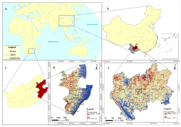
Fig. 1 Maps of central Yunnan Province (CYP), China and eastern South Africa (ESA): (a) Relative positions of the CYP and ESA; (b) Location of the CYP; (c) Location of the ESA; (d) elevation of the CYP; (e) elevation of the ESA.

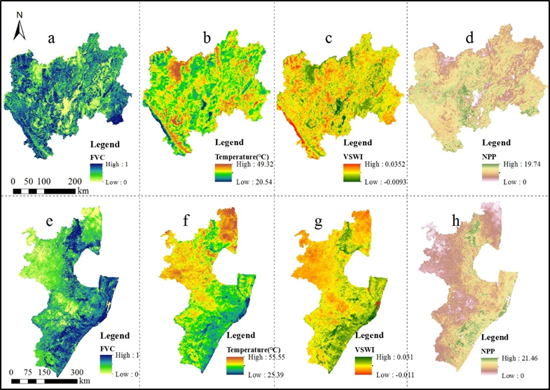
Fig. 2 Moderate Resolution Imaging Spectroradiometer (MODIS) data processing results: (a) Fractional vegetation cover (FVC) in central Yunnan Province (CYP), China; (b) Surface temperature in the CYP; (c) Vegetation Water Supply Index (VWSI) in CYP; (d) Net Primary Production (NPP) in the CYP; (e) FVC in eastern South Africa (ESA); (f) Surface temperature in the ESA; (g) VWSI in the ESA; (h) NPP in the ESA.
论文得到了王金亮教授主持的国家重点研发计划多政府国际科技创新合作重点项目 “利用地理空间技术进行土地利用/土地覆盖变化对生态安全影响的环境监测与评估”(2018YFE0184300),云南省高校科技创新团队(IRTSTYN),俄罗斯基础研究基金(19-55-80010\19),南非国家研究基金(120456)和国家自然科学基金(41561048)共同资助。
这是刘兰芳同学读硕士研究生以来发表的首篇 SCI/SCIE 学术论文,是她的硕士期间发表的第一篇学术论文(详见录 1、2),也是王金亮教授导师团队 2022年的发表第14篇 SCI/SCIE 论文(详见录 3),让我们恭喜刘兰芳同学!希望她再接再厉!也热烈祝贺团队取好成绩!
附录 1 论文相关信息
标题:The establishment of an eco-environmental evaluation model for southwest China and eastern South Africa based on the DPSIR framework
作者:Lanfang Liua,b,c, Jie Lia,b,c,Jinliang Wanga,b,c,*, Fang Liua,b,c, Janine Coled , Jinming Shae , Yuanmei Jiaoa,b,c , Jingchun Zhoua,b,c
通讯作者:Jinliang Wang
作者单位:
a Faculty of Geography, Yunnan Normal University, Kunming 650500, China
b Key Laboratory of Resources and Environmental Remote Sensing for Universities in Yunnan, Kunming 650500, China
c Center for Geospatial Information Engineering and Technology of Yunnan Province, Kunming 650500, China
d Council for Geoscience, Pretoria 0001, South Africa
e School of Geographical Science, Fujian Normal University, Fuzhou 350007, China
出版物: Ecological Indicators
摘要:The establishment of a standard and unified evaluation system model and its application to a cross-regional eco-environmental quality evaluation and analysis are required for identifying patterns of change in eco-environmental quality in different regions and the driving factors. This knowledge is important for achieving sustainable development. This study used remote sensing (RS) data and geographic information science (GIS) to construct a unified eco-environmental quality evaluation index system based on the Driving Forces, Pressure, State, Impact and Response (DPSIR) framework and the Analytic Hierarchy Process (AHP), the Entropy method, and Grey Relational Analysis (GRA). The index system was applied to evaluate the eco-environmental quality of central Yunnan Province (CYP) and eastern South Africa (ESA) at the county scale and to identify driving factors. The results showed that: (1) The mean ecological quality index of all counties (districts/cities) in the ESA in 2019 was 0.3696, which was slightly higher than that of 0.3449 in the CYP, indicating similar total ecological quality between the CYP and ESA. (2) The Moran's I value of eco-environmental quality in the CYP and ESA both exceeded 0, with significant spatial agglomerations. (3) The strongest correlations were between state class indicators and eco-environmental quality in both study areas. The grey relational coefficients exceeded 0.9, representing state indicators (such as vegetation coverage, habitat quality index, remote-sensed vegetation water supply index, vegetation net primary productivity, and annual mean precipitation) as the main driving forces of eco-environmental quality.
关键字:Eco-environmental evaluation; DPSIR framework; Grey Relational Analysis; Central Yunnan Province; Eastern South Africa
附录2 刘兰芳同学发表SCI论文清单
自2021年9月攻读硕士至今,刘兰芳同学在王金亮教授指导下发表了1篇SCI学术论文,信息如下:
[1] Lanfang Liu, Jie Li, Jinliang Wang*, Fang Liu, Janine Cole , Jinming Sha , Yuanmei Jiao , Jingchun Zhou. The establishment of an eco-environmental evaluation model for southwest China and eastern South Africa based on the DPSIR framework [J]. Ecological Indicators, 2022,145, 109687. DOI: https://doi.org/10.1016/j.ecolind.2022.109687. (中科院SCI期刊分区:2021年12月最新基础版二区,升级版二区,2022年IF 6.263)
附录 3 王金亮团队 2022 年 1 月至目前发表论文清单
自2022年1月至11月18日,王金亮教授团队发表学术论文18篇,其中14篇SCI/SCIE 论文、4篇CSCD论文,具体信息如下:
[18] Lanfang Liu, Jie Li, Jinliang Wang*, Fang Liu, Janine Cole , Jinming Sha , Yuanmei Jiao , Jingchun Zhou. The establishment of an eco-environmental evaluation model for southwest China and eastern South Africa based on the DPSIR framework [J]. Ecological Indicators, 2022,145, 109687. DOI: https://doi.org/10.1016/j.ecolind.2022.109687. (中科院SCI期刊分区:2021年12月最新基础版二区,升级版二区,2022年IF 6.263)
[17]Yuncheng Deng, Jiya Pan, Jinliang Wang*, Qianwei Liu, Jianpeng Zhang. Mapping of Forest Biomass in Shangri-La City Based on LiDAR Technology and Other Remote Sensing Data[J]. Remote Sensing, 2022,14,5816. DOI: https://doi.org/10.3390/rs14225816. (中科院SCI期刊分区:2021年12月最新基础版二区,升级版二区,2022年IF 5.349)
[16]邓云程,王金亮*,刘钱威,冯宝坤,张建鹏.提取林木胸径的F-LS算法[J].遥感信息,2022, 37(5): 77-84. DOI: https://doi.org/10.3969/j.issn.1000-3177.2022.05.012 (CSCD核心库)
[15] Yongcui Lan, Jinliang Wang*, Wenying Hu, Eldar Kurbanov, Janine Cole, Jinming Sha, Yuanmei Jiao, Jingchun Zhou. Spatial pattern prediction of forest wildfire susceptibility in Central Yunnan Province, China based on multivariate data[J]. Natural Hazards, 2022, Online. DOI: https://doi.org/10.1007/s11069-022-05689-x. (中科院SCI期刊分区:2021年12月最新基础版三区,升级版三区,2021年IF 3.158)
[14] Jiya Pan , Cheng Wang, Jinliang Wang* , Fan Gao, Qianwei Liu , Jianpeng Zhang, and Yuncheng Deng. Land Cover Classification Using ICESat-2 Photon Counting Data and Landsat 8 OLI Data: A Case Study in Yunnan Province, China[J]. IEEE Geoscience and Remote Sensing Letters, 2022. DOI: https://doi.org/10.1109/LGRS.2022.3209725. (中科院SCI期刊分区:2021年12月基础版三区,升级版二区,2021年IF 5.343)
[13] Suling He, Jie Li, Jinliang Wang*, and Fang Liu. Evaluation and analysis of upscaling of different Land Use /Land Cover products (FORM-GLC30, GLC_FCS30, CCI_LC, MCD12Q1 and CNLUCC): a case study in China[J]. Geocarto International, 2022. DOI: 10.1080/10106049.2022.2127926. (中科院SCI期刊分区:2021年12月基础版二区,升级 版,2021年IF 4.889)
[12]Juncheng Shi, Cheng Wang, Jinliang Wang*, Xiaohuan Xi*, Xuebo Yang, and Xue Ding*. Study on the LAI and FPAR inversion of maize from airborne LiDAR and hyperspectral data[J] INTERNATIONAL JOURNAL OF REMOTE SENSING 2022, VOL. 43, NO. 13, 4793-4809 HTTPS://DOI.ORG/10.1080/01431161.2022.2121187. (中科院SCI期刊分区: 2021年12月最新基础版三区,升级版三区;2021年IF 3.531)
[11] Chen Y, Wang J*, Kurbanov E, Thomas A, Sha J, Jiao Y, et al. Ecological security assessment at different spatial scales in central Yunnan Province, China[J]. PLoS ONE, 2022, 17(6): e0270267. DOI: https://doi.org/10.1371/journal.pone.0270267. (中科院SCI期刊分区:2021年12月基础版三区,升级版三区;2022年最新IF 3.752)
[10] Jiya Pan, Jinliang Wang*, Fan Gao, and Guangjie Liu. Quantitative estimation and influencing factors of ecosystem soil conservation in Shangri-La, China[J]. Geocarto International, 2022. DOI: https://doi.org/10.1080/10106049.2022.2091160. (中科院SCI期刊分区:2021年12月基础版二区,升级版三区;2021年IF 4.889)
[9] Jianpeng Zhang, Jinliang Wang*, Feng Cheng, Weifeng Ma, Qianwei Liu, Guangjie Liu. Natural forest ALS-TLS point cloud data registration without control points[J]. Journal of Forestry Research, 2022, Online. DOI:https://doi.org/10.1007/s11676-022-01499-w. (中科院SCI期刊分区:2021 年12月基础版SCIE二区,升级版SCIE二区;2021年IF 2.149)
[8] PAN, J. Y. ,WANG, J. L.* , LIU, G. J. ,GAO, F. Estimation of ecological asset values in Shangri_la based on remotely sensed data [J]. Applied ecology and environmental research, 2022, 20(4):2879-2895. DOI: http://dx.doi.org/10.15666/aeer/2004_28792895 . (中科院SCI 期刊分区:2021年12月基础版SCIE四区,升级版SCIE四区;2020-2021最新IF: 0.711)
[7]Jie Li, Suling He, Jinliang Wang*, Weifeng Ma, Hui Ye. Investigating the spatiotemporal changes and driving factors of nighttime light patterns in RCEP Countries based on remote sensed satellite images [J]. Journal of Cleaner Production, 2022, 131944. DOI: https://doi.org/10.1016 /j.jclepro.2022.131944. (中科院SCI期刊分区:2021年12月基础版SCIE一区,升级版 SCIE一区;Top:是;2020-2021最新IF: 9.297)
[6]何苏玲,王金亮*,角媛梅,周京春,农兰萍,朱泓.国土空间规划视角下资源环境承载力评价分析——以昆明市为例[J], 中国农业资源与区划, 2021,43(4): 119-127. DOI: 10.7621 /CJARRP. 1005-9121. 20220413 (CSCD核心库; CSSCI)
[5]潘继亚, 王金亮*, 高帆. 滇西北高山峡谷典型区土地利用变化与生态安全评价 研究 [J]. 生态科学, 2022, 41(2): 29–40. (CSCD扩展库,北大核心)
[4] Jie Li, Jinliang Wang*, Jun Zhang, Chenli Liu, Suling He, Lanfang Liu. Growing-season vegetation coverage patterns and driving factors in the China-Myanmar Economic Corridor based on Google Earth Engine and geographic detector [J]. Ecological Indicators, 2022, 136, 108620. DOI: doi.org/10.1016/j.ecolind.2022.108620. (中科院 SCI 期刊分区:2021年12 月基础版 SCIE二区,升级版SCIE二区;2022最新IF: 6.263)
[3]农兰萍,王金亮*,玉院和.基于地理加权回归模型和不同植被特征参数的 TRMM 3B43 降尺度研究——以云南省为例[J].兰州大学学报(自然科学版), 2022, 58(01): 99-110+117. DOI:10.13885/j.issn.0455-2059.2022.01.011. ( CSCD 核心库)
[2] Jianpeng Zhang, Jinliang Wang*, Pinliang Dong, Weifeng Ma, Yicheng Liu, Qianwei Liu, Zhiyan Zhang. Tree stem extraction from TLS point-cloud data of natural forests based on geometric features and DBSCAN[J]. Geocarto International, Published online: 08 Feb 2022. DOI: 10.1080/10106049.2022.2034988 (中科院SCI期刊分区:2021年12月基础版SCIE区,升级版SCIE三区;2021年IF 4.889)
[1] Yuanhe Yu, Xingqi Sun, Jinliang Wang*, Jianpeng Zhang. Using InVEST to evaluate water yield services in Shangri-La, Northwestern Yunnan, China[J]. Peer J, 2022, online. DOI: doi.org/10.7717/peerj.12804 (中科院 SCI期刊分区:2021年12月基础版SCIE三区,升级版SCIE三区;2020-2021年IF: 2.984)
(云南高校资源与环境遥感重点实验室 供稿)
地址:云南省昆明市呈贡区云南师范大学旅游与地理科学学院413
邮箱:ynnurs@163.com 电话:0871-65941202 技术支持:蓝队云
版权所有:Copyright © 2016-2018 云南省高校资源与环境遥感重点实验室. All Rights Reserved