王金亮导师团队学术论文在SCIE期刊PLoS One上线发表
2022年6月28日,以陈云(云南师范大学地理学部自然地理学专业2019级硕士研究生,2019年9月-2022年5月为中科院西北生态环境资源研究院自然地理学专业博士研究生,现为中科院西北生态环境资源研究院博士后)为第一作者,王金亮教授为通讯作者所撰写的题为“Ecological security assessment at different spatial scales in central Yunnan Province, China”的学术论文在SCI/SCIE期刊PLoS One(2021年中科院SCI分区:三区;2022年IF 3.752)上线发表(https://doi.org/10.1371/journal.pone.0270267)。
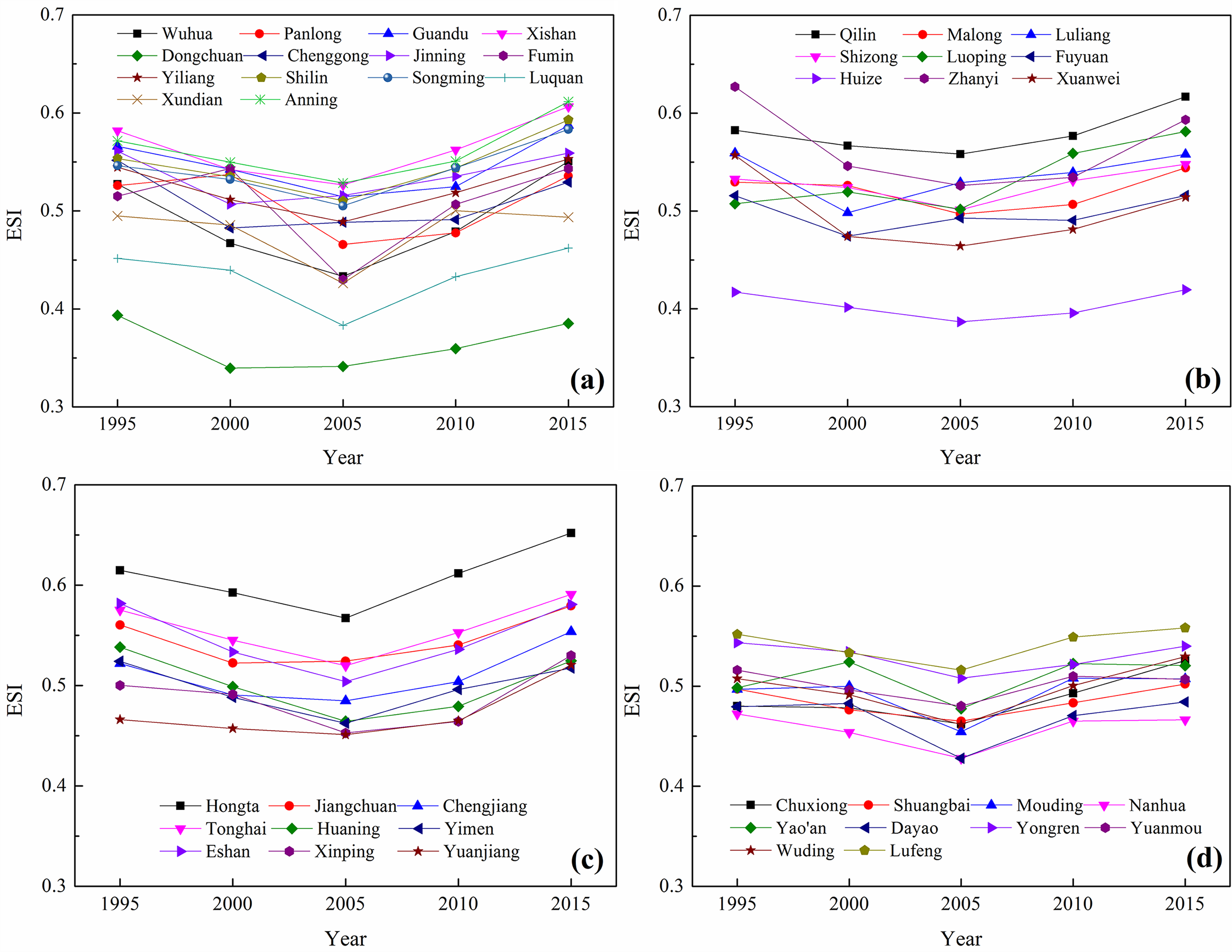
滇中城市群是云南省的社会经济中心,是云南融入“一带一路”倡议和国家“两横三纵”城镇化战略格局的重要组成部分,是黄土高原-川滇生态屏障保护和建设区的重要组成部分。同时,也是人口、工业等最集中的地区,自然环境开发利用强度较高和资源消耗程度较大,资源自给能力较弱,土地资源供需矛盾尖锐。在滇中地区开展生态安全评价对社会经济可持续发展具有重要意义。研究基于驱动力、压力、状态、影响和响应(DPSIR)模型,利用1995年、2000年、2005年、2010年和2015年的遥感数据、社会经济统计数据和实地调查数据,建立了生态安全评估指标体系。基于多级加权综合指数法,在1km×1km像素尺度和县域尺度上对滇中城市群进行了生态安全评价。结果表明:(1)以2005年为转折点,滇中地区生态安全状况先下降后上升;(2)县域尺度下生态安全主要为不安全,在像素尺度下生态不安全和相对不安全的区域主要分布在滇中中部、北部和西部;(3)生境破碎化、自然地理条件差异和人口集聚导致生态安全恶化和空间差异加剧。研究结果可以为快速城市化地区经济发展和环境保护的协调与可持续性提供一定的依据。


Figure1.Study area

Figure 2. Patterns of ecological security levels in central Yunnan Province at the pixel level.

Figure 3. Values and change trends of ecological security index in central Yunnan Province at the county level.
该论文得到了王金亮教授主持的国家重点研发计划政府间国际科技创新合作重点专项:用地理空间技术监测和评估土地利用/土地覆被变化对区域生态安全的影响(2018YFE0184300)、国家自然基金项目(41561048)、云南省高校高原山地资源环境遥感监测与评估科技创新团队(IRTSTYN)的资助;同时,还得到了俄罗斯基础研究基金会(RFBR:19-55-80010\19)、南非国家研究基金会(NRF:120456)的联合资助。
这是陈云同学读硕士研究生以来发表的第三篇SCI/SCIE学术论文(详见录1)、王金亮教授导师团队2022年发表的第八篇SCI/SCIE论文(详见录2)。在此,让我们恭喜陈云同学!希望他再接再厉!也热烈祝贺团队取好成绩!
论文相关信息
标题:Ecological security assessment at different spatial scales in central Yunnan Province, China
通讯作者:Jinliang Wang
作者单位:
1 Faculty of Geography, Yunnan Normal University, Kunming, China
2 Northwest Institute of Eco-Environment and Resources, Chinese Academy of Sciences, Lanzhou, China
3 Key Laboratory of Resources and Environmental Remote Sensing for Universities in Yunnan, Kunming, China
4 Remote Sensing Research Laboratory, Center for Geospatial Information Engineering and Technology of Yunnan Province, Kunming, China
5 Center for Sustainable Forest Management and Remote Sensing, Volga State University of Technology, Yoshkar-Ola, Russia
6 Council for Geoscience, Pretoria, South Africa
7 College of Geographical Science, Fujian Normal University, Fuzhou, China
出版物:PLoS One
摘要:Healthy ecosystems are the basis of social and economic development. It is of great significance to conduct ecological security assessments in rapidly urbanization areas. Based on the driving forces, pressure, state, impact, and response (DPSIR) model, five years (1995, 2000, 2005, 2010 and 2015) of remote sensing images, social and economic statistics, and field survey data were used to establish an ecological security assessment index system. The ecological security assessment of central Yunnan Province (CYP) urban agglomeration was conducted at the 1 km × 1 km pixel scale and at the county scale based on the multilevel weighted comprehensive index method. The results showed that: (1) With 2005 as the turning point, the ecological security situation in CYP first decreased and then increased. (2) The ecological security at the county scale was mainly categorized as unsafe. At the pixel scale, ecologically unsafe and relatively unsafe areas were mainly distributed in central, northern, and western CYP. (3) The ecological security deterioration and strengthened spatial distribution differences were caused by habitat fragmentation, different physical geographical conditions, and population agglomeration. These results can provide a basis for the coordination and sustainability of economic development and environmental protection in urban agglomerations with rapid urbanization.
关键词:ecological security; patterns; temporal change; DPSIR model; central Yunnan Province
附录1 陈云同学硕士期间发表SCI论文清单
自2016年9月攻读硕士至今,陈云在王金亮教授指导下共发表了3篇SCI学术论文,具体信息如下:
[3] Chen Y, Wang J*, Kurbanov E, Thomas A, Sha J, Jiao Y, et al. Ecological security assessment at different spatial scales in central Yunnan Province, China[J]. PLoS ONE, 2022, 17(6): e0270267.
DOI: https://doi.org/10.1371/journal.pone.0270267. (中科院三区,2022年最新IF 3.752)
[2] 2. Chen Y, Wang J*. Ecological security early-warning in central Yunnan Province, China, based on the gray model[J]. Ecological Indicators. 2020. 111, 106000.
DOI: https://doi.org/10.1016/j.ecolind.2019.106000 (中科院二区,2022年最新IF 6.263)
[1] Chen Y, Wang J*, Liu G, Yang Y, Liu Z, Deng H. Hyperspectral estimation model of forest soil organic matter in northwest Yunnan Province, China[J]. Forests, 2019, 10(3), 217.
DOI: https://doi.org/ 10.1016/j.ecolind.2019.106000. (中科院二区,2022年IF 3.282)
附录2 王金亮团队2022年1月至今发表论文清单
[10] Chen Y, Wang J*, Kurbanov E, Thomas A, Sha J, Jiao Y, et al. Ecological security assessment at different spatial scales in central Yunnan Province, China[J]. PLoS ONE, 2022, 17(6): e0270267.
DOI: https://doi.org/10.1371/journal.pone.0270267. (中科院SCI期刊分区:2021年12月基础版三区,升级版三区;2022年最新IF 3.752)
[9] Jiya Pan, Jinliang Wang*, Fan Gao, and Guangjie Liu. Quantitative estimation and influencing factors of ecosystem soil conservation in Shangri-La, China[J]. Geocarto International, 2022.
DOI: https://doi.org/10.1080/10106049.2022.2091160. (中科院SCI期刊分区:2021年12月基础版二区,升级版三区;2021年IF 4.889)
[8] Jianpeng Zhang, Jinliang Wang*, Feng Cheng, Weifeng Ma, Qianwei Liu, Guangjie Liu. Natural forest ALS-TLS point cloud data registration without control points[J]. Journal of Forestry Research, 2022, Online.
DOI:https://doi.org/10.1007/s11676-022-01499-w. (中科院SCI期刊分区:2021年12月基础版SCIE二区,升级版SCIE二区;2021年IF 2.149)
[7] Pan, J. Y. ,Wang, J. L.*, Liu, G. J. ,Gao, F. Estimation of ecological asset values in Shangri_la based on remotely sensed data [J]. Applied ecology and environmental research, 2022, 20(4):2879-2895.
DOI: http://dx.doi.org/10.15666/aeer/2004_28792895 . (中科院SCI期刊分区:2021年12月基础版SCIE四区,升级版SCIE四区;2020-2021最新IF: 0.711)
[6]Jie Li, Suling He, Jinliang Wang*, Weifeng Ma, Hui Ye. Investigating the spatiotemporal changes and driving factors of nighttime light patterns in RCEP Countries based on remote sensed satellite images [J]. Journal of Cleaner Production, 2022, 131944.
DOI: https://doi.org/10.1016 /j.jclepro.2022.131944. (中科院SCI期刊分区:2021年12月基础版SCIE一区,升级版SCIE一区;Top:是;2020-2021最新IF: 9.297)
[5]潘继亚, 王金亮, 高帆. 滇西北高山峡谷典型区土地利用变化与生态安全评价研究[J]. 生态科学, 2022, 41(2): 29–40. (北大核心, CSCD扩展库)
[4] Jie Li, Jinliang Wang*, Jun Zhang, Chenli Liu, Suling He, Lanfang Liu. Growing-season vegetation coverage patterns and driving factors in the China-Myanmar Economic Corridor based on Google Earth Engine and geographic detector [J]. Ecological Indicators, 2022, 136, 108620.
DOI: https://doi.org/10.1016/j.ecolind.2022.108620. (中科院SCI期刊分区:2021年12月基础版SCIE二区,升级版SCIE二区;2022最新IF: 6.263)
[3]农兰萍,王金亮,玉院和.基于地理加权回归模型和不同植被特征参数的TRMM 3B43降尺度研究——以云南省为例[J].兰州大学学报(自然科学版), 2022, 58(01): 99-110+117.
DOI:10.13885/j.issn.0455-2059.2022.01.011. ( CSCD核心库)
[2] Jianpeng Zhang, Jinliang Wang*, Pinliang Dong, Weifeng Ma, Yicheng Liu, Qianwei Liu, Zhiyan Zhang. Tree stem extraction from TLS point-cloud data of natural forests based on geometric features and DBSCAN[J]. Geocarto International, Published online: 08 Feb 2022.
DOI: 10.1080/10106049.2022.2034988 (中科院SCI期刊分区:2021年12月基础版SCIE二区,升级版SCIE三区;2021年IF 4.889)
[1] Yuanhe Yu, Xingqi Sun, Jinliang Wang*, Jianpeng Zhang. Using InVEST to evaluate water yield services in Shangri-La, Northwestern Yunnan, China[J]. Peer J, 2022, online.
DOI: https://doi.org/10.7717/peerj.12804 (中科院SCI期刊分区:2021年12月基础版SCIE三区,升级版SCIE三区;2020-2021年IF: 2.984)
(供稿:云南省高校资源与环境遥感重点实验室)
地址:云南省昆明市呈贡区云南师范大学旅游与地理科学学院413
邮箱:ynnurs@163.com 电话:0871-65941202 技术支持:蓝队云
版权所有:Copyright © 2016-2018 云南省高校资源与环境遥感重点实验室. All Rights Reserved