王金亮导师团队学术论文在SCIE二区期刊Journal of Forestry Research上线发表
2022年6月17日,以张建鹏(云南师范大学地理学部地图学与地理信息系统专业2021级博士研究生)为第一作者,王金亮教授为通讯作者撰写题为 “Natural forest ALS-TLS point cloud data registration without control points” 论文在SCI/SCIE期刊Journal of Forestry Research (2021中科院SCI分区:二区,2021年IF : 2.149)上线发表(https://link.springer.com/article /10.1007/s11676-022-01499-w)。
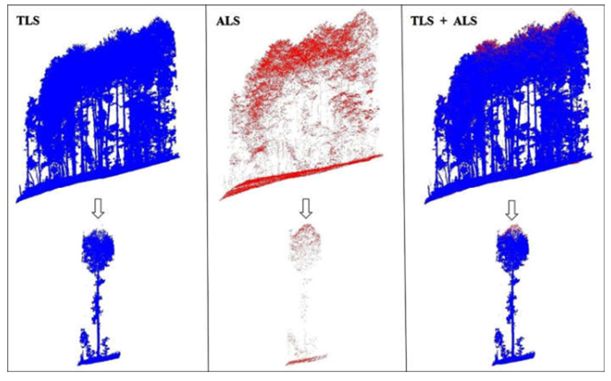
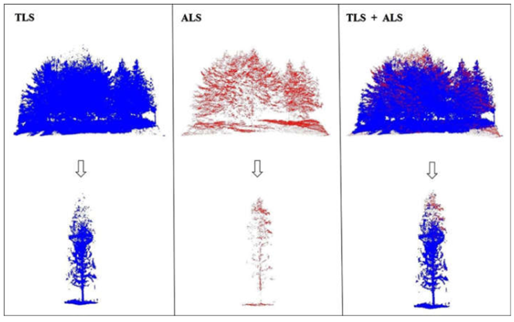
机载激光雷达 (Airborne laser scanning, ALS) 和地面激光雷达(Terrestrial laser scanning TLS)在其森林参数调查和研究应用能力方面引起了研究人员的关注。但是由于天然林中树木的遮挡,ALS难以获取森林冠层以下的精细结构信息,而TLS 难以获取关于上层树冠精细的 结构信息。为了解决利用ALS或TLS单一平台采集天然林点云数据不完整的问题,本研究提出了一种在无控制点的条件下ALS和TLS点云配准的方法:首先,根据样地大小对ALS 和 TLS 原始数据进行裁剪,将ALS点云数据转换为以裁剪数据中心为原点的相对坐标;然后,选择ALS 和 TLS 数据的相同特征点对实现点云数据粗配准;最后,通过迭代最近点(ICP)算法对粗配准结果进行优化,得到ALS和TLS数据的高精度配准结果。研究以两块不同树种、不同生长环境的云南松和云杉样地为研究对象进行试验,结果表明,该方法实现了ALS和TLS点云数据的高精度配准,其中,云南松的平均配准精度为0.06m, 云杉平均配准精度为0.09m。

Fig.1 TLS and ALS fine registration results for Pinus yunnanensis

Fig.2 TLS and ALS fine registration results for Picea asperata
该论文得到了王金亮教授主持的国家自然基金项目:联合ULS与TLS点云数据的滇西北天然林单木生物量估算研究(41961060)、云南省高校高原山地资源环境遥感监测与评估科技创新团队(IRTSTYN)项目资助,以及云南省教育厅科学研究基金项目(NO.2020J0256、NO.2021J0438)、云南师范大学研究生科研创新基金项目(NO.YJSJJ21-A08)资助。
这是张建鹏同学读博士研究生以来发表的第二篇SCI学术论文(详见录1)、王金亮教授导师团队2022年的第六篇SCIE论文(详见录2),让我们恭喜张建鹏同学!希望他再接再厉!也热烈祝贺团队取得好成绩!
论文相关信息
标题:Natural forest ALS-TLS point cloud data registration without control points
作者:Jianpeng Zhang1,2,3, Jinliang Wang1,2,3*, Feng Cheng1,2,3, Weifeng Ma1,2,3, Qianwei Liu1,2,3, Guangjie Liu4
通讯作者:Jinliang Wang
作者单位:
1Faculty of Geography, Yunnan Normal University, Kunming 650500, China;
2Key Laboratory of Resources and Environmental Remote Sensing for Universities in Yunnan, Kunming 650500, Yunnan, China;
3Center for Geospatial Information Engineering and Technology of Yunnan Province, Kunming 650500, Yunnan, China;
4College of Resources and Environment, Yunnan Agriculture University, Kunming 650201, People’s Republic of China.
出版物:Journal of Forestry Research
摘要:Airborne laser scanning (ALS) and terrestrial laser scanning (TLS) has attracted attention due to their forest parameter investigation and research applications. ALS is limited to obtaining fine structure information below the forest canopy due to the occlusion of trees in natural forests. In contrast, TLS is unable to gather fine structure information about the upper canopy. To address the problem of incomplete acquisition of natural forest point cloud data by ALS and TLS on a single platform, this study proposes data registration without control points. The ALS and TLS original data were cropped according to sample plot size, and the ALS point cloud data was converted into relative coordinates with the center of the cropped data as the origin. The same feature point pairs of the ALS and TLS point cloud data were then selected to register the point cloud data. The initial registered point cloud data was finely and optimally registered via the iterative closest point (ICP) algorithm. The results show that the proposed method achieved high precision registration of ALS and TLS point cloud data from two natural forest plots of Pinus yunnanensis Franch. And Picea asperata Mast. which included different species and environments. An average registration accuracy of 0.06 m and 0.09 m were obtained for P. yunnanensis and P. asperata, respectively.
关键词:Airborne laser scanning (ALS) ; Terrestrial laser scanning (TLS) ; Registration; Natural forest; Iterative closest point (ICP) algorithm
附录1 张建鹏同学博士研究生期间发表论文清单
2021年9月博士入学至今,张建鹏在王金亮教授指导下发表了SCI论文2篇。论文信息如下:
[2] Jianpeng Zhang, Jinliang Wang*, Feng Cheng, Weifeng Ma, Qianwei Liu, Guangjie Liu. Natural forest ALS-TLS point cloud data registration without control points[J]. Journal of Forestry Research, 2022, Published: 17 June 2022
DOI:https://doi.org/10.1007/s11676-022-01499-w. (2021年12月基础版二区,升级版二区,2021年IF 2.149)
[1] Jianpeng Zhang, Jinliang Wang*, Pinliang Dong, Weifeng Ma, Yicheng Liu, Qianwei Liu, Zhiyan Zhang. Tree stem extraction from TLS point-cloud data of natural forests based on geometric features and DBSCAN[J]. Geocarto International, 2022, Online.
DOI: https://doi.org/10.1080/10106049.2022.2034988. (2021年12月基础版二区,升级版三区,2021年IF 4.889)
附录2 王金亮教授团队2022年1月至目前发表论文清单
[8] Jianpeng Zhang, Jinliang Wang*, Feng Cheng, Weifeng Ma, Qianwei Liu, Guangjie Liu. Natural forest ALS-TLS point cloud data registration without control points[J]. Journal of Forestry Research, 2022, Online.
DOI:https://doi.org/10.1007/s11676-022-01499-w. (SCIE,二区,2021年IF 2.149)
[7] Pan, J. Y. Wang, J*. L. Liu, G. J. Gao, F. Estimation of ecological asset values in Shangri la based on remotely sensed data [J]. Applied ecology and environmental research, 2022, 20(4):2879-2895.
DOI: http://dx.doi.org/10.15666/aeer/2004_28792895. (SCIE 四区,2020-2021最新IF: 0.711)
[6] Jie Li, Suling He, Jinliang Wang*, Weifeng Ma, Hui Ye. Investigating the spatiotemporal changes and driving factors of nighttime light patterns in RCEP Countries based on remote sensed satellite images [J]. Journal of Cleaner Production, 2022, 131944.
DOI: https://doi.org/10.1016 /j.jclepro.2022.131944. (SCIE,一区,Top,2020-2021最新IF: 9.297)
[5]潘继亚, 王金亮*, 高帆. 滇西北高山峡谷典型区土地利用变化与生态安全评价研究[J]. 生态科学, 2022, 41(2): 29–40. (北大核心, CSCD扩展库)
[4] Jie Li, Jinliang Wang*, Jun Zhang, Chenli Liu, Suling He, Lanfang Liu. Growing-season vegetation coverage patterns and driving factors in the China-Myanmar Economic Corridor based on Google Earth Engine and geographic detector [J]. Ecological Indicators, 2022, 136, 108620.
DOI: https://doi.org/10.1016/j.ecolind.2022.108620. (SCIE,二区,2020-2021最新IF: 4.958)
[3]农兰萍,王金亮*,玉院和.基于地理加权回归模型和不同植被特征参数的TRMM 3B43降尺度研究——以云南省为例[J].兰州大学学报(自然科学版), 2022, 58(01): 99-110+117.
DOI:10.13885/j.issn.0455-2059.2022.01.011. ( CSCD核心库)
[2] Jianpeng Zhang, Jinliang Wang*, Pinliang Dong, Weifeng Ma, Yicheng Liu, Qianwei Liu, Zhiyan Zhang. Tree stem extraction from TLS point-cloud data of natural forests based on geometric features and DBSCAN[J]. Geocarto International, Published online: 08 Feb 2022.
DOI: 10.1080/10106049.2022.2034988. (2021中科院SCI基础版二区、升级版三区,IF: 4.889)
[1] Yuanhe Yu, Xingqi Sun, Jinliang Wang*, Jianpeng Zhang. Using InVEST to evaluate water yield services in Shangri-La, Northwestern Yunnan, China[J]. PeerJ, 2022, online.
DOI: https://doi.org/10.7717/peerj.12804 (SCIE,三区,2020-2021年IF: 2.984)
(供稿:云南省高校资源与环境遥感重点实验室)
地址:云南省昆明市呈贡区云南师范大学旅游与地理科学学院413
邮箱:ynnurs@163.com 电话:0871-65941202 技术支持:蓝队云
版权所有:Copyright © 2016-2018 云南省高校资源与环境遥感重点实验室. All Rights Reserved