王金亮导师小组论文在SCI/SCIE二区期刊Computers and Electronics in Agriculture上线发表
2021年9月28日,以刘钱威(云南师范大学地理学部,地图学与地理信息系统专业2019级硕士研究生)为第一作者、王金亮教授为通讯作者撰写题为“Target-free ULS-TLS point-cloud registration for alpine forest lands”论文在SCI/SCIE期刊Computers and Electronics in Agriculture(二区,2020年IF 5.565)上线发表(https://doi.org/10.1016/j.compag.2021.106460)。
机载激光雷达与地基激光雷达具有互补的扫描视角,将两者的源数据进行配准可以获取更为完整的森林点云数据,对于提取森林信息具有重大帮助。然而受数据密度、扫描的林分冠层形状不一致等方面影响,两者的配准面临难题。研究以香格里拉市作为研究区,提出一种树高点配准方法,该方法从DSM(Digital Surface Model)中获取树高点,搜索配对树高点,通过SVD(Singular Value Decomposition)分解获取旋转与平移矩阵完成粗配准,最后通过最邻近点迭代SVD分解实现精配准。结果表明:(1)该方法在本文的样地中平均精度为0.43m,平均运行时间不超过1s,在斜坡(2~18°)林地中具有较好的适用性。(2)通过探究树干点搜索窗口变化的影响,发现3m*3m最为适合。

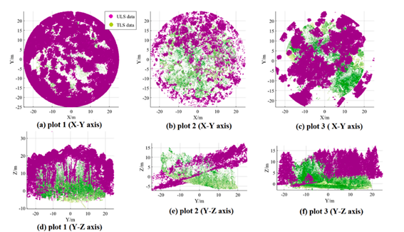
Fig. 1. The ULS and TLS point cloud data before registration.

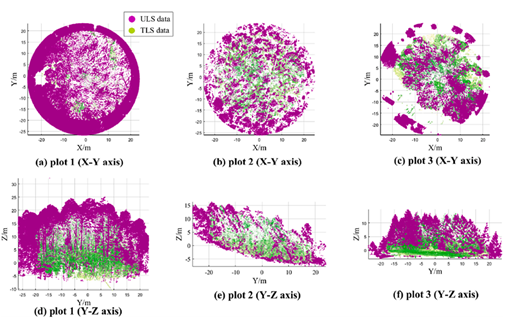
Fig. 2. The ULS and TLS point cloud data after the final registration
该论文得到了王金亮教授主持的国家自然基金项目 “联合ULS与TLS点云数据的滇西北天然林单木生物量估算研究(批准号:41961060)”、国家重点研发计划政府间国际科技创新合作重点专项“用地理空间技术监测和评估土地利用/土地覆被变化对区域生态安全的影响(立项编号:2018YFE0184300)”、云南基础研究重点项目“北回归线(云南)旅游大健康产业地理环境科学考察(批准号:2019FA017)”和云南省高校高原山地资源环境遥感监测与评估科技创新团队(IRTSTYN)的资助。
这是刘钱威同学进入硕士研究生阶段发表的第4篇论文(详见附录1)。希望刘钱威再接再厉!也热烈祝贺团队取得好成绩!
截止2021年9月28日,王金亮团队2021年发表学术论文22篇,其中SCIE论文7篇,CSCD论文15篇(详见附录2、附录3)。
论文相关信息
标题:Target-free ULS-TLS point-cloud registration for alpine forest lands
作者:Qianwei Liua,b,c, Jinliang Wanga,b,c, Weifeng Maa,b,c, Jianpeng Zhanga,b,c, Yuncheng Denga,b,c, Dajiang Shaoa,b,c, Dongfan Xud, Yicheng Liua,b,c
通讯作者:Jinliang Wang
作者单位:
aFaculty of Geography, Yunnan Normal University, Kunming 650500, Yunnan, China
bKey Laboratory of Resources and Environmental Remote Sensing for Universities in Yunnan, Kunming 650500, Yunnan, China
cCenter for Geospatial Information Engineering and Technology of Yunnan Province, Kunming 650500, Yunnan, China
dForestry College, Southwest Forestry University, Kunming 650224, Yunnan, China
出版物:Computers and Electronics in Agriculture
摘要:Modern laser scanning techniques have been commonly used for forest land studies. Complementary scanning capabilities can be particularly obtained using unmanned aerial vehicle laser scanning (ULS) and terrestrial laser scanning (TLS) technologies. The registration of the ULS and TLS data can thus lead to more comprehensive data acquisition and information extraction in forest lands. However, this registration process is typically hindered by problems of data density and inconsistency of the scanned forest canopy shape. In this paper, we propose a tree height registration (TR) method for ULS-TLS point-cloud registration, and apply this method to the alpine forest land of the Shangri-La City of the Northwestern Yunnan Province in China. The tree height points are obtained from a digital surface model (DSM), which contains isosurface points of the forest structures. Rotation and translation matrices are then calculated through singular value decomposition (SVD), and rough registration is completed. Finally, fine registration is achieved through nearest-neighbor iterative SVD. The results show that the proposed method can effectively register ULS and TLS forest data samples, with an average accuracy of 0.43m. The method has an average running time of less than 21 s through 3m-by-3m window size to search tree height point for registration, and also shows good applicability in forest lands with slopes in the range of 2-18◦.Moreover, the best outcomes were obtained for a 3m-by-3m window size.
关键词:Keywords;Registration;TLS;ULS;DSM;Tree-height;SVD
附录1 刘钱威同学发表4篇论文清单
[4] Qianwei Liu, Jinliang Wang*, Weifeng Ma, Jianpeng Zhang, Yuncheng Deng, Dajiang Shao, Dongfan Xu, Yicheng Liu. Target-free ULS-TLS point-cloud registration for alpine forest lands[J]. Computers and Electronics in Agriculture, 2021, 190, 106460,
DOI: https://doi.org/10.1016/j.compag.2021.106460. (SCIE 二区,2020年IF 5.565)
[3] 刘钱威,王金亮*, 麻卫峰, 张建鹏. 一种复杂背景下林木点云精细提取方法[J], 测绘科学, 2021, 46(8), 105-111. (CSCD,核心库)
[2] Qianwei Liu, Weifeng, Jianpeng Zhang, Yicheng Liu, Dongfan Xu, Jinliang Wang*. Point‑cloud segmentation of individual trees in complex natural forest scenes based on a trunk‑growth method[J],Journal of Forestry Research
DOI: https://doi.org/10.1007/s11676-021-01303-1 (SCIE 三区,2019年IF1.689)
(Published: 04 March 2021)
[1]刘钱威, 王金亮, 玉院和. 基于遥感数据的北回归线云南段旅游气候适宜性评价研究[J].云南大学学报(自然科学版), 2020, 42(05), 906-915. (CSCD,核心库)
附录2 王金亮导师团队2021年发表7篇SCIE论文清单
截止2021年9月28日,王金亮导师团队2021年已经发表SCI论文7篇。信息如下:
[7]Qianwei Liu, Jinliang Wang*, Weifeng Ma, Jianpeng Zhang, Yuncheng Deng, Dajiang Shao, Dongfan Xu, Yicheng Liu. Target-free ULS-TLS point-cloud registration for alpine forest lands[J]. Computers and Electronics in Agriculture, 2021, 190, 106460,
DOI: https://doi.org/10.1016/j.compag.2021.106460. (SCIE 二区,2020年IF 5.565)
[6]Yuanhe Yu, Yuzhen Shen, Jinliang Wang*, Yuchun Wei, Zhiyuan Liu. Simulation and mapping of drought and soil erosion in Central Yunnan Province, China[J].Advances in Space Research
DOI: https://doi.org/10.1016/j.asr.2021.08.028 (SCI三区, 2020年IF 2.152)
(Online August 30, 2021)
[5]Jinliang Wang, Yuanhe Yu*. Comprehensive drought monitoring in Yunnan Province, China using multisource remote sensing data[J]. Journal of Mountain Science, 2021, 18(6):1537-1549.
DOI: https://doi.org/10.1007/s11629-020-6333-7 (SCIE三区, 2019年IF 1.550)
(Online June 17, 2021)
[4]Jie Li, Jinliang Wang*, Jun Zhang, Jianpeng Zhang, Han Kong.Dynamic changes of vegetation coverage in China-Myanmar economic corridor over the past 20 years[J], International Journal of Applied Earth Observation and Geoinformation
DOI: https://doi.org/10.1016/j.jag.2021.102378 (SCIE一区,Top期刊,2019年IF 4.650)
(Online June 8, 2021)
[3]Fang Liu, Wanbin Wang, Jinliang Wang*, Xingzi Zhang, Jing Ren, Yuexiong Liu. Multi- scale Analysis of the Characteristics of the Changing Landscape of the Typical
Mountainous Region of Southwest China over the Past 40 Years[J], Peer J
DOI: https://doi.org/10.7717/peerj.10923 (SCIE 三区,2019年 IF 2.380)
(Published May 14, 2021)
[2]Yuanhe Yu, Yuzhen Shen, Jinliang Wang*, Yuchun Wei*, Lanping Nong & Huan Deng. Assessing the response of vegetation change to drought during 2009–2018 in Yunnan Province, China[J], Environmental Science and Pollution Research
DOI: https://doi.org/10.1007/s11356-021-13835-4 (SCIE 三区,2019年IF3.056)
(Published: 22 April 2021)
[1]Qianwei Liu, Weifeng, Jianpeng Zhang, Yicheng Liu, Dongfan Xu, Jinliang Wang*. Point‑cloud segmentation of individual trees in complex natural forest scenes based on a trunk‑growth method[J],Journal of Forestry Research
DOI: https://doi.org/10.1007/s11676-021-01303-1 (SCIE 三区,2019年IF1.689)
(Published: 04 March 2021)
附录3 王金亮导师团队2021年发表15篇CSCD和中文核心论文清单
截止2021年9月28日,王金亮导师团队2021年已经发表中文学术论文信息如下:
[15] 祁兰兰,王金亮*,农兰萍,刘钱威.基于GF-1卫星数据的洱海干季水质时空变化监测[J/OL].人民长江:1-8[2021-09-28].https://doi.org/10.16232/j.cnki.1001-4179.2021.09.005. (北大核心)
[14]祁兰兰,王金亮*,叶辉,朱泓.滇中“三湖流域”土地利用景观格局与水质变化关系研究[J/OL].水土保持研究: 1-10[2021-09-08]. https://doi.org/10.13869/j.cnki.rswc.20210831.001. (CSCD, 扩展库)
[13]农兰萍,王金亮*,玉院和.基于改进型遥感生态指数(MRSEI)模型的滇中地区生态环境质量研究[J].生态与农村环境学报, 2021, 37(08), 972-982. DOI:10.19741/j.issn.1673-4831.2020.0821
(CSCD, 核心库)
[12] YE Hui,BAl Die,TAN Shucheng, SHAO Dajiang, WANG Jinliang*. Evaluating the Ecological Security of Land Resources based on Multi-source Data in the Altay Region of China[J]. Journal of Resources and Ecology, 2021,12(6): 757–765. (CSCD, 核心库)
[11]何苏玲,王金亮*.国土空间规划视角下资源环境承载力评价分析——以昆明市为例[J], 中国农业资源与区划, 2021, 网络首发时间:2021-07-13 11:25:56。网络首发地址: https://kns.cnki.net /kcms/detail/11.3513.S.20210713.1111.006.html (CSCD, 核心库)
[10]麻卫峰,王金亮,麻源源,赵锦平.一种改进的输电线模型参数求解方法[J].测绘工程, 2021, 30(04): 20-25+34.
[9]何苏玲,邹凤琼,王金亮*.基于AHP和MSE赋权法的龙南县生态敏感性评价[J/OL].生态学杂志: 1-12[2021-06-14]. 网络首发地址:https://doi.org/10.13292/j.1000-4890.202109.022. (CSCD,核心库)
[8]刘钱威,王金亮*, 麻卫峰, 张建鹏.一种复杂背景下林木点云精细提取方法[J], 测绘科学, 2021, 46(8):105-111. DOI:10. 16251/j cnki 1009—2307.202108 015. (CSCD,核心库)
[7]麻卫峰,王成,王金亮,麻源源.点云数据温度变化环境下输电线形态模拟[J].电力系统保护与控制, 2021,49(09):90-96.
[6]麻卫峰,王成,王金亮,麻源源,张建鹏.基于激光点云的高压输电线覆冰厚度反演[J].电力系统保护与控制, 2021,49(04):89-95. (CSCD, 核心库)
[5]刘一成,王成,习晓环,王金亮,张海清.距离加权与冠层控制的LiDAR CHM凹坑去除方法[J].测绘科学,2021,46(04):108-113. (CSCD, 核心库)
[4]叶辉,王金亮*,赵娟娟.基于DPSIR-EES模型的北回归线(云南段)生态安全评价[J].水土保持研究,2021,28(03):291-298. (CSCD, 扩展库)
[3]张艳可,王金亮*,苏怀,程峰.基于CART决策树的双尺度流域单元地貌分类研究——以北回归线(云南段)地区为例[J].地理与地理信息科学,2021,37(02):84-92.(CSCD, 核心库)
[2]张建鹏,王成,王金亮*.点云密度和体素大小对单木LAI反演的影响[J].遥感信息, 2021, 36(01): 112-119.(CSCD, 核心库)
[1]张艳可,王金亮*,农兰萍,程峰,张云峰.基于MODIS
地址:云南省昆明市呈贡区云南师范大学旅游与地理科学学院413
邮箱:ynnurs@163.com 电话:0871-65941202 技术支持:蓝队云
版权所有:Copyright © 2016-2018 云南省高校资源与环境遥感重点实验室. All Rights Reserved