王金亮导师研究小组的论文在SCI期刊Journal of the Indian Society of Remote Sensing上发表
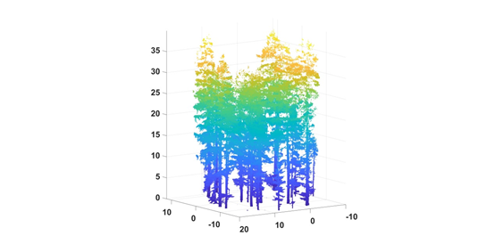
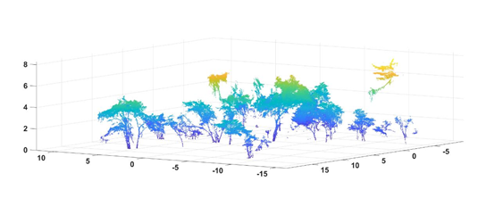
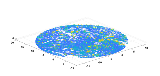
2020年08月26日,以云南省高校资源与环境遥感重点实验室2018级硕士研究生张建鹏为第一作者、王金亮教授为通讯作者撰写题为“Vertical Structure Classification of a Forest Sample Plot Based on Point Cloud Data”的论文在SCI期刊Journal of the Indian Society of Remote Sensing上发表(DOI: 10.1007/s12524-020-01149-w, 文章链接:https://rdcu.be/b6sEz)。该论文基于地面激光雷达获取的香格里拉森林点云数据,利用形态学滤波和比较最短路径点云分割算法,实现了天然林点云数据在垂直方向上的分层提取:乔木、灌木和地面。

乔木点云提取结果

灌木点云提取结果

地面点云提取结果
该论文得到了王金亮教授主持国家自然科学基金(No.41961060, No.41271230)、欧盟文化执行署(EACEA伊拉斯谟+国际高等教育能力建设项目 “遥感教育与学习创新(No.586037-EPP-1-2017-1-HU-EPPKA2-CBHE-JP)、云南省中青年学术技术带头人(No.2008PY056)、云南省高校科技创新团队支持计划(IRTSTYN)的资助。
标题:Vertical Structure Classification of a Forest Sample Plot Based on Point Cloud Data
作者:Jianpeng Zhang, Jinliang Wang, Guangjie Liu
通讯作者:Jinliang Wang, jlwang@ynnu.edu.cn
作者单位:1. College of Tourism and Geographic Sciences, Yunnan Normal University, Kunming 650500, China; 2. Key Laboratory of Resources and Environmental Remote Sensing, Universities in Yunnan, Kunming 650500, China; 3. Remote Sensing Research Laboratory, Center for Geospatial Information Engineering and Technology of Yunnan Province, Kunming 650500, China.
出版物:Journal of the Indian Society of Remote Sensing
摘要:The vertical structure of forests affects energy transfer and material exchange within forest ecosystems and is of great significance to scientific forestry and ecology research. In this paper, the Shangri-La forest plot in northwestern Yunnan Province of China was the study area. The forest sample plot point cloud data were obtained by terrestrial laser scanning technology. A new method for classifying the vertical structure of forest sample plots based on point cloud data is proposed. The method comprehensively utilizes morphological filtering and comparative shortest-path (CSP) algorithm point cloud segmentation technology. Additionally, the method proposes the concept of secondary CSP segmentation that precisely classifies three types of vertical features in forest point cloud data: trees, shrubs and the ground. Finally, an accuracy analysis showed that the error rate of the tree results was 1.87%, and the error rate of the shrub results was 16.23%.
关键字:Morphological filtering; Point cloud segmentation; Shangri-La; TLS; Vertical structure
地址:云南省昆明市呈贡区云南师范大学旅游与地理科学学院413
邮箱:ynnurs@163.com 电话:0871-65941202 技术支持:蓝队云
版权所有:Copyright © 2016-2018 云南省高校资源与环境遥感重点实验室. All Rights Reserved