资源与环境遥感团潘继亚学术论文在SCIE二区期刊Journal of Geodesy上线发表
2024年9月4日,以潘继亚为第一作者,王金亮教授为通讯作者所撰写的题为“A main direction-based noise removal algorithm for ICESat-2 photon-counting LiDAR data”的学术论文在SCIE二区期刊Journal of Geodesy上线发表(https://doi.org/10.1007/s00190-024 -01887-6)
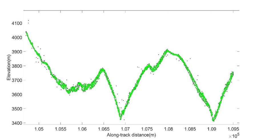
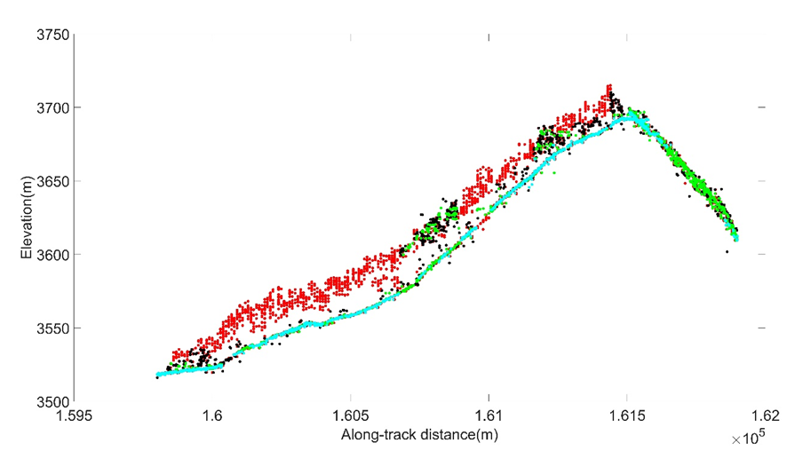
新一代星载激光雷达冰、云和陆地测高卫星ICESat-2(Ice, Cloud, and land Elevation Satellite-2)搭载了先进光子计数式激光雷达系统ATLAS(Advanced Topographic Laser Altimeter System)可进行高程剖面式的对地观测,但该数据包含大量噪声,如何有效实现光子点云去噪成为数据应用的关键。研究以涵盖日间和夜间的森林、裸地、水域、建设用地等地面类型的3组光子数据为研究对象,提出一种基于点云主方向的ICESat-2光子数据去噪算法。首先,将光子点云按照沿轨和高程方向划分格网,去除明显的噪声光子,并根据点云行列数,将二维剖面点云转化为三维点云。然后,通过计算光子点云空间邻域内特征来提取点云主方向,根据主方向与沿轨方向的夹角实现光子点云二次去噪。最后,利用改进的局部统计距离算法去除剩余噪声点,实现数据噪声的完全滤除,利用混淆矩阵进行精度验证,并将基于点云主方向去噪算法与ATL03数据不同置信度光子、ATL08产品的去噪分类结果进行对比。结果表明:(1)该算法能够处理日间及夜间不同信噪比的数据,且在多种地形结构下去噪精度均能达到96%以上,特别是夜间数据,去噪精度能达到97.43%;(2)该算法去噪结果与ATL03置信度为中高低(Conf=2/3/4)的光子一致,去噪精度优于ATL08产品数据;(3)该算法参数少,去噪效率明显高于DBSCAN(Density-Based Spatial Clustering of Applications with Noise)和改进的局部统计距离去噪算法。本文基于点云主方向的去噪算法为后续光子点云数据处理提供了参考。
该论文得到了王金亮教授主持的云南省科技重大专项(西南联合研究生院科技专项基础研究与应用基础研究重大专项,批准号 202302AO370003);国家自然科学基金项目(批准号41961060);云南省高校高原山地资源环境遥感监测与评估科技创新团队(IRTSTYN);潘继亚主持的云南省教育厅青年人才基础研究专项(批准号2024J0136)的共同资助。
这是潘继亚近五年来以第一作者发表的第4篇SCIE论文(详见附录1、附录2),此篇论文也是王金亮教授导师团队2024年发表的第11篇SCIE/SSCI论文(详见附录3)。让我们恭喜潘继亚!希望她再接再厉!也热烈祝贺资源与环境遥感研究团队取好成绩!
附录 1 论文相关信息
标题:A main direction-based noise removal algorithm for ICESat-2 photon-counting LiDAR data
作者:Jiya Pan 1,2,3 , Fan Gao 4 , Jinliang Wang 2,3,5,*, Jianpeng Zhang 2,3,5, Qianwei Liu6 and Yuncheng Deng 2,3,5
通讯作者:Jinliang Wang
作者单位:
1 School of Economics , Yunnan Normal University, Kunming 650500, China.
2 Key Laboratory of Resources and Environmental Remote Sensing for Universities in Yunnan, Kunming 650500, China.
3 Center for Geospatial Information Engineering and Technology of Yunnan Province, Kunming 650500, China.
4 Yunnan Minzu University, Kunming 650500, China.
5 Faculty of Geography, Yunnan Normal University, Kunming 650500, China.
6 Yunnan Data and Application Center of China High-resolution Earth Observation System, Kunming 650000, China.
出版物:Journal of Geodesy(中科院SCI期刊分区:2023年12月最新升级版二区,2024年IF:3.9)
摘要:A new generation of space-borne LiDAR (Light Detection And Ranging) satellite ICESat-2 (Ice, Cloud, and land Elevation Satellite-2) equipped with ATLAS (Advanced Topographic Laser Altimeter System) can perform earth observation. The main problem is to remove the noise photons from the data. The study proposes a main direction-based noise removal algorithm based on three sets of photon-counting LiDAR data. In order to extract the main direction, features in the spatial neighbourhood (k) of photons are calculated, most of the initial noise is removed according to the angle between the main direction of photons and the along-track distance direction. Qualitative and quantitative evaluations are employed to validate the proposed algorithm. The obtained results and the performed analysis reveal that the proposed algorithm can process day and night data with different signal-to-noise ratios, while the accuracy of various surface types exceeds 96%. More specifically, the accuracy of the proposed algorithm for night data can reach 97.43%. Based on quantitative evaluations using SPL (Single photon LiDAR), MATLAS, and airborne LiDAR data, the average R, P, and F values are 0.951, 0.959, and 0.954, respectively. Meanwhile, the result of the proposed algorithm is compatible with the ATL03 photons with low, medium, and high confidence, and its accuracy is superior to ATL08 products. The proposed algorithm had fewer parameters and significantly outperformed the Density-Based Spatial Clustering of Applications with Noise (DBSCAN) and the improved local statistical distance algorithm. This algorithm is expected to provide a reference for subsequent photon-counting LiDAR data processing.
关键词:noise removal; ATL03; ATL08; main direction; photon-counting LiDAR
附录 2 潘继亚发表论文清单
自2019年9月至今,潘继亚在王金亮教授指导下共发表了5篇学术论文,其中SCIE论文4篇,信息如下:
[5] Jiya Pan, Fan Gao, Jinliang Wang*, Jianpeng Zhang, Qianwei Liu, and Yuncheng Deng.A noise removal algorithm based on the main direction for ICESat-2 photon-counting LiDAR data[J]. Journal of Geodesy, 2024,98(80).(SCIE,IF:3.9)
[4] Jiya Pan, Cheng Wang, Jinliang Wang*, Fan Gao, Qianwei Liu , Jianpeng Zhang, and Yuncheng Deng.Land Cover Classification Using ICESat-2 Photon Counting Data and Landsat 8 OLI Data: A Case Study in Yunnan Province, China[J]. IEEE Geoscience and Remote Sensing Letters, 2022.(SCIE,IF:5.343)
[3] Jiya Pan, Jinliang Wang*, Fan Gao ,and Guangjie Liu.Quantitative estimation and influencing factors of ecosystem soil conservation in Shangri-La, China[J]. Geocarto International, 2022.(SCIE,IF:3.450)
[2] Pan, J. Y., Wang, J. L.*, Liu, G. J., Gao, F. Estimation of ecological asset values in Shangrila based on remotely sensed data [J]. Applied ecology and environmental research, 2022, 20(4):2879-2895.(SCIE,IF:0.816)
[1] 潘继亚, 王金亮*, 高帆. 滇西北高山峡谷典型区土地利用变化与生态安全评价研究[J]. 生态科学, 2022, 41(2): 29-40.(CSCD)

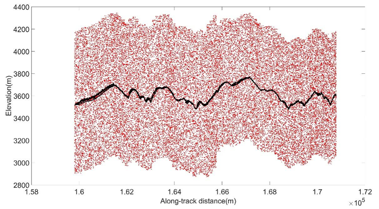

(a) Data1


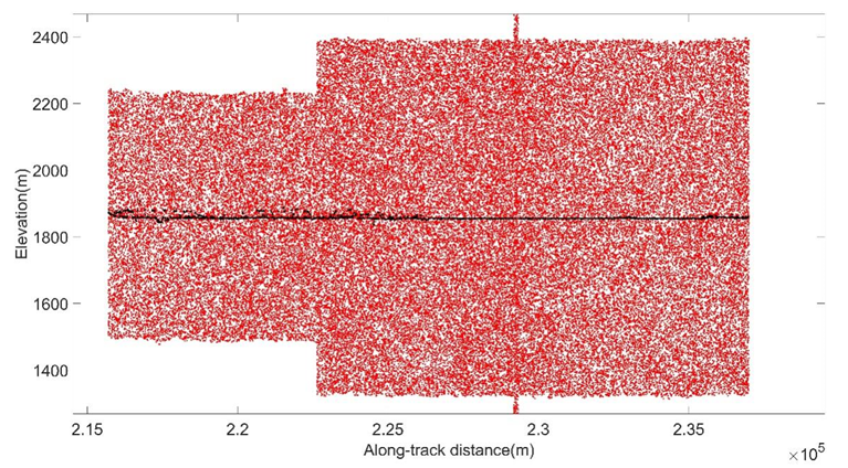
(b) Data2


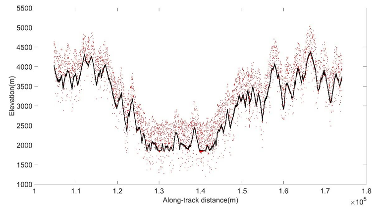
(c) Data3
Fig.1 Noise removal of ICESat-2/ATLAS: (a) denoising of day photons in the forest; (b) denoising of day photons in urban and water; (c) denoising of night photons in the forest, barren, and water.

![]()
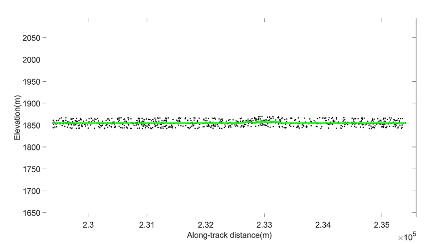
(a) Data2(Day)
![]()
![]()
![]()


(b) Data3(Night)
Fig.2 Comparing the ATL08 algorithm with the main direction-based noise removal algorithm; (a) enlarged views of Data2; (b) enlarged views of Data3.
![]()


(a)

![]()
![]()
![]()

(b)


(c)

![]()
![]()


(d)
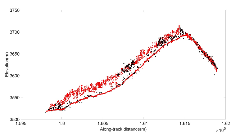
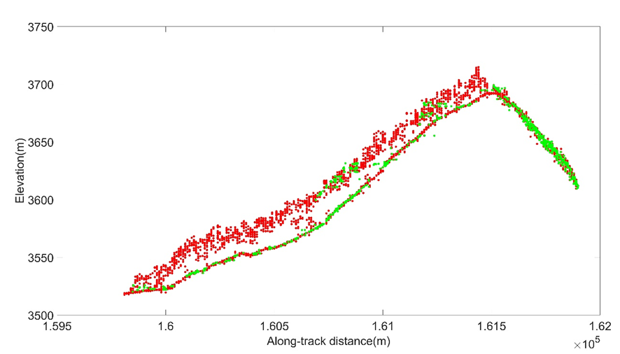
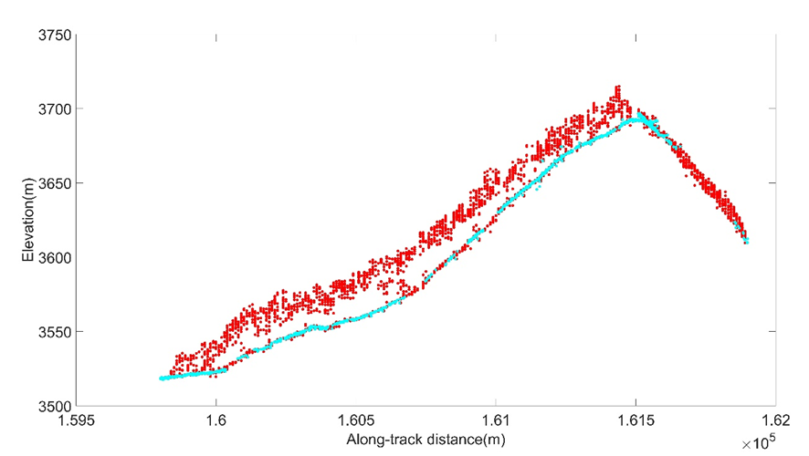
Fig.3 Comparison between the main direction-based noise removal algorithm and ATL03 algorithm with photons with different confidence levels; (a) compares the performance of the main direction-based noise removal algorithm with that of the ATL03 algorithm using low, medium, and high confidence level photons (Conf=2/3/4); (b) compares the performance of the main direction-based noise removal algorithm with that of the ATL03 algorithm for low confidence level (Conf=2) photons; (c) compares the performance of the main direction-based noise removal algorithm with that of the ATL03 algorithm using medium confidence (Conf=3) photons; (d) compares the main direction-based noise removal algorithm with the ATL03 algorithm with photons with high confidence levels (Conf=4).
![]()
![]()


(a)

![]()
![]()

(b)
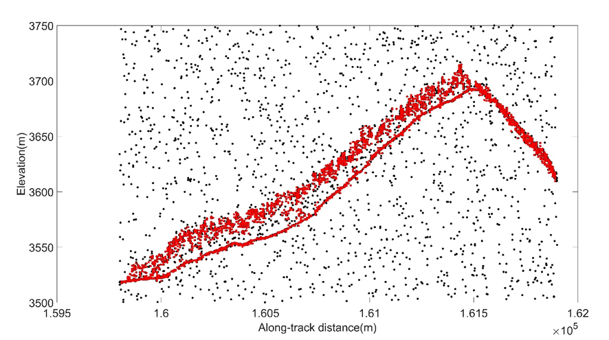
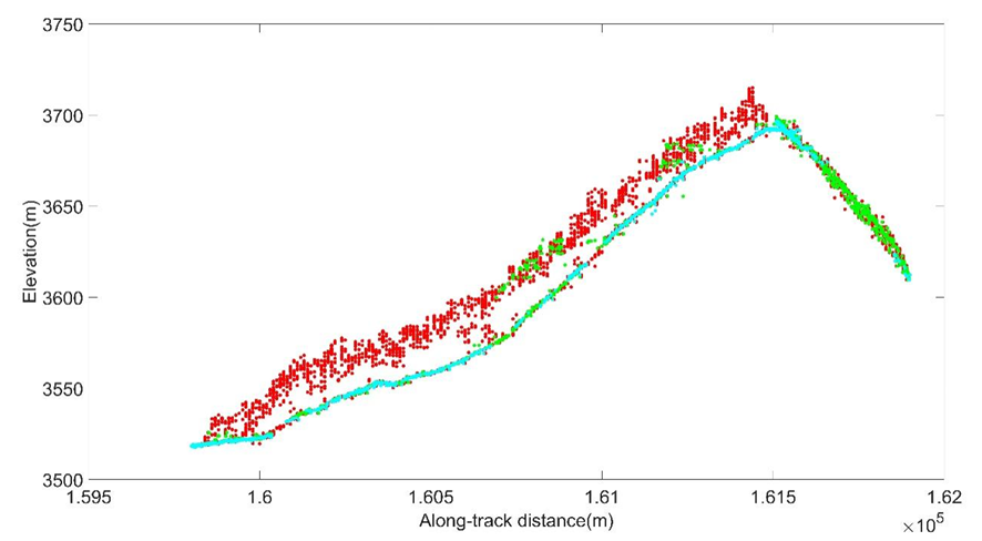
Fig.4 The performance of the main-direction-based noise removal algorithm to identify the noise photons inside the canopy: (a) the data before and after denoising; (b) the main direction-based noise removal algorithm with the ATL03 algorithm using medium and high confidence level photons.


![]()
![]()
![]()
(a)

![]()
![]()
![]()
![]()

(b)
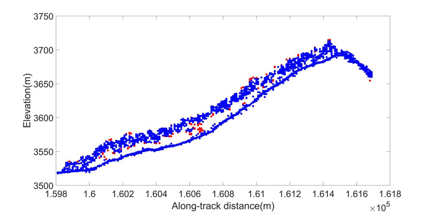
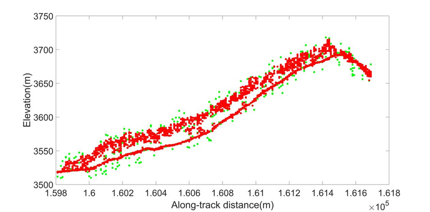
Fig.5 The denoising result comparison of different noise removal algorithms: (a) the main-direction-based noise removal algorithm and the improved local statistical distance algorithm; (b) the main-direction-based noise removal algorithm and DBSCAN.
附录 3 王金亮教授团队2024年发表SCIE/SSCI论文清单
自2024年01月01日至09月04日,王金亮教授导师团队发表SCIE/SSCI学术论文12篇(仅统计王金亮教授为通讯作者的论文),其中SCIE论文10篇、SSCI论文1篇。具体信息如下:
[12] Jiya Pan, Fan Gao, Jinliang Wang*, Jianpeng Zhang, Qianwei Liu, and Yuncheng Deng.A noise removal algorithm based on the main direction for ICESat-2 photon-counting LiDAR data[J]. Journal of Geodesy, 2024,98(80). https://doi.org/10.1007/s00190-024 -01887-6 (中科院SCI期刊分区:2023年12月最新分区二区,IF:3.9)
[11]Jun Ma, Jinliang Wang*, Suling He, Jianpeng Zhang, Lanfang Liu, Xuzheng Zhong. Direct and indirect effects of urbanization on vegetation: A survey of Yunnan central urban Economic Circle, China[J].Ecological Indicators, Volume 166, 2024, 112536.https://doi.org/10.1016/j.ecolind.2024.112536. (中科院SCI期刊分区:2023年12月最新分区二区,IF:7.0)
[10] Fang Liu, Qian Zhang, Jinliang Wang*, Yuexiong Liu, Wanbin Wang, Sen Li. Ecological security assessment of Yunnan Province, China in the context of Production-Living-Ecological Space division[J]. Ecology and Evolution. 2024.14, e70131.https://doi.org/10.1002/ece3. 70131 (中科院SCI期刊分区:2023年12月最新分区二区,IF:2.3)
[9] Liu, S.; Deng, Y.; Zhang, J.; Wang, J.*; Duan, D. Extraction of Arbors from Terrestrial Laser Scanning Data Based on Trunk Axis Fitting[J]. Forests,2024,15,1217.https:// doi.org/10.3390/f15071217 (中科院SCI期刊分区:2023年12月最新分区二区,IF:2.4)
[8] Jie Li, Jinliang Wang*, Suling He, ChenliLiu, Lanfang Liu. Using Knowledge Graphs to Analyze the Characteristics and Trends of Forest Carbon Storage Research at the Global Scale [J]. ISPRS International Journal of Geo-Information, 2024, 13(7), 234.DOI: https://doi.org/10.3390/ijgi13070234. (中科院SCI期刊分区:2023年12月最新升级版三区,2024年IF:2.8)
[7] Suling He, Jinliang Wang*, Jie Li, Jinming Sha, Jinzhun Zhou, Yuanmei Jiao, Quantification and Simulation of the Ecosystem Service Value of Karst Region in Southwest China[J], Land, 2024, 13(6): 812. https://doi.org/10.3390/land13060812. (中科院SCI期刊分区:2023年 12月最新升级版SSCI二区,2024年IF:3.9)
[6] Lanfang Liu, Yan Liu, Feng Cheng, Yuanhe Yu, Jinliang Wang*, Cheng Wang , Lanping Nong, Huan Deng, Remote sensing estimation of regional PM2.5 Based on GTWR Model:A case study of southwest China[J], Environmental Pollution, 2024, 124057. https://doi.org/10. 1016/j.envpol.2024.124057 (中科院SCI期刊分区:2023年12月最新升级版二区Top期刊,2024年IF:8.9)
[5] Rafael Antonio Chaparro Torres, Jinliang Wang*, Jianpeng Zhang, Lanfang Liu, Yongcui Lan, Temporal analysis of land degradation and urban expansion in central Yunnan Province using remote sensing for supporting sustainable development goals 11/15[J], Ecological Indicators, Volume 163, 2024,112058. https://doi.org/10.1016/j.ecolind.2024.112058. (中科院SCI期刊分区:2023年12月最新升级版二区Top期刊,2024年IF:6.9)
[4] Gao,Y., Wang, J. *, Liu, S. *, Yao,X., Qi, M., Liang,P., Xie,F., Mu,J., Ma, X. Monitoring dynamics of Kyagar Glacier surge and repeated draining of Ice-dammed lake using multi-source remote sensing[J].Science of The Total Environment,2024,172467. https://doi.org/10.1016/j.scitotenv.2024.172467. (中科院SCI期刊分区:2023年12月最新升级版一区Top期刊,2024年IF :9.8)
[3] Xu, Haichao, Rongqing Han, Jinliang Wang*, and Yongcui Lan. Temporal–Spatial Characteristics and Influencing Factors of Forest Fires in the Tropic of Cancer (Yunnan Section) [J].Forests, 2024, 15, 661. https://doi.org/10.3390/f15040661 (中科院SCI期刊分区:2023年12月最新升级版二区,2024年IF:2.9)
[2] Yanke Zhang, Tengfei Gu, Suling He, Feng Cheng,Jinliang Wang*, et al. Extreme drought along the tropic of cancer (Yunnan section) and its impact on vegetation[J]. Scientific reports, 2024, 14, 7508. https://doi.org/10.1038/s41598-024-58068-w. (中科院SCI期刊分区:2023年12月最新升级版二区,2024年IF:4.6)
[1] Di Duan, Yuncheng Deng, Jianpeng Zhang, Jinliang Wang*, et al. Influence of VF and SOR-Filtering Methods on Tree Height Inversion Using Unmanned Aerial Vehicle LiDAR Data[J]. Drones, 2024, 8(4), 119. https://doi.org/10.3390/drones8040119. (中科院SCI期刊分区:2023年12月最新升级版二区,2024年IF:4.8)
(云南省高校资源与环境遥感重点实验室 供稿)
地址:云南省昆明市呈贡区云南师范大学旅游与地理科学学院413
邮箱:ynnurs@163.com 电话:0871-65941202 技术支持:蓝队云
版权所有:Copyright © 2016-2018 云南省高校资源与环境遥感重点实验室. All Rights Reserved